2013-12-18 34 -118
From Geohashing
Revision as of 22:53, 18 December 2013 by imported>Bravissimo594 ([live picture] Made it, and got to play with a puppy in the picnic area. [http://www.openstreetmap.org/?lat=34.15780000&lon=-118.30000000&zoom=16&layers=B000FTF @34.1578,-118.3000])
| Wed 18 Dec 2013 in 34,-118: 34.1578549, -118.2998052 geohashing.info google osm bing/os kml crox |
Location
Rancho Avenue, just north of the Bette Davis Picnic Area in Griffith Park.
Participants
Plans
Bravissimo594 and Boppy plan to drive to the location sometime between 2:30pm and 3:30pm.
Expedition
Tracklog
Photos
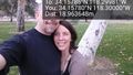
Made it, and got to play with a puppy in the picnic area. @34.1578,-118.3000

Achievements