2015-05-13 52 1
From Geohashing
Revision as of 20:45, 13 May 2015 by imported>Sourcerer ([live picture] Major drainage dyke between me and the hashpoint. [http://www.openstreetmap.org/?lat=52.55318642&lon=1.53140187&zoom=16&layers=B000FTF @52.5532,1.5314])
| Wed 13 May 2015 in 52,1: 52.5542541, 1.5312650 geohashing.info google osm bing/os kml crox |
Location
Participants
Plans
Expedition
Tracklog
Photos
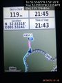
Major drainage dyke between me and the hashpoint. @52.5532,1.5314

Achievements