2015-03-02 35 -82
From Geohashing
Revision as of 02:34, 20 June 2015 by imported>Mcbaneg (Created page with "<!-- If you did not specify these parameters in the template, please substitute appropriate values for IMAGE, LAT, LON, and DATE (YYYY-MM-DD format) {{{image|dummy.jpg}}}|...")

| Mon 2 Mar 2015 in 35,-82: 35.3778320, -82.4158358 geohashing.info google osm bing/os kml crox |
Location
pasture near Fruitland Road, Hendersonville, NC, USA
Participants
Expedition
Another spring-break-visiting-Mom expedition. We had met friends at Chimney Rock State Park for a hike, and before heading home we decided to try for this geohash that was just a few miles away. It was visible from the road, but in a pasture with access only via an obviously-private muddy road that led past some houses. We took a photo from the entrance and called it good.
Photos
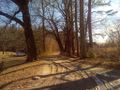
Road leading to pasture.
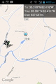
Geohash Droid screenshot from that position. We did get a little closer by returning south along Fruitland Road, so our closest approach was probably 350 m or so.
