2017-12-18 60 24
| Mon 18 Dec 2017 in 60,24: 60.2537090, 24.9752368 geohashing.info google osm bing/os kml crox |
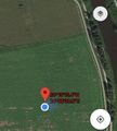
Location
The hash was in the middle of a field in Tuomarinkylä, Helsinki
Participants
Expedition
With some time for a longer walk, we started walking through the suburbs towards the hash. After crossing the river Vantaanjoki, we continued walking the path between the river and the field. We estimated the point on the bath based on aerial photos and the streets on the other side of the river. The condition of not harming the crops was decided to be met since the field was ploughed and mostly covered with snow that held weight. We continued (almost) straight to the hash with the help of GPS. The hash seemed to be in the wettest part of the field but luckily it was between two puddles so our feet stayed dry.
Photos
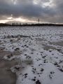
The dryish spot in between
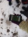
The spot and dry feet
GPS
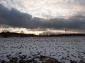
An unexpected ligth on the sky
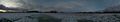
Panorama view from the hash
Tuomarinkylä manor

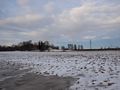
Towards the hash and River Vantaanjoki from a bridge

Mallards


Achievements