2018-05-26 -37 175
From Geohashing
Revision as of 02:59, 26 May 2018 by imported>Krintar ([live picture]Hash point is down a steep hill in private property. This is the closest point I could reach without trespassing. [http://www.openstreetmap.org/?lat=-37.04125940&lon=175.02145690&zoom=16&layers=B000FTF @-37.0413,175.0215])
| Sat 26 May 2018 in -37,175: -37.0413542, 175.0203118 geohashing.info google osm bing/os kml crox |
Location
Participants
Plans
Expedition
Tracklog
Photos
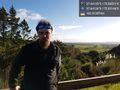
Hash point is down a steep hill in private property. This is the closest point I could reach without trespassing. @-37.0413,175.0215

Achievements