File:2011-06-02 48 9 Trueb directions.JPG
From Geohashing
Revision as of 17:29, 30 January 2020 by Maintenance script (talk | contribs) (Maintenance script uploaded File:2011-06-02 48 9 Trueb directions.JPG)

Size of this preview: 450 × 600 pixels. Other resolutions: 180 × 240 pixels | 1,500 × 2,000 pixels.
Original file (1,500 × 2,000 pixels, file size: 549 KB, MIME type: image/jpeg)
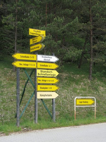
Directions lead to:
- Alb barracks
- Vehicle cleaning facility
- Shooting lane 5-15
- Hospital Albstadt
- Special Facility f-l-i-h
- Shooting lane 1-4
- Site shooting facility
- Special Facility e-a-c-d
- bivuoak site
- Fighters lane
- Camp Heuberg
I don't think this includes any place one would intentionally go...
File history
Click on a date/time to view the file as it appeared at that time.
| Date/Time | Thumbnail | Dimensions | User | Comment | |
|---|---|---|---|---|---|
| current | 17:29, 30 January 2020 | | 1,500 × 2,000 (549 KB) | Maintenance script (talk | contribs) |
- You cannot overwrite this file.
File usage
The following page links to this file: