File:2023-08-01 53 9 - 08 Drone pano north.JPG
From Geohashing

Size of this preview: 799 × 154 pixels. Other resolutions: 320 × 62 pixels | 6,994 × 1,349 pixels.
Original file (6,994 × 1,349 pixels, file size: 4.89 MB, MIME type: image/jpeg)
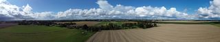
A panorama of the north of the 2023-08-01 53 9 hash via drone.
File history
Click on a date/time to view the file as it appeared at that time.
| Date/Time | Thumbnail | Dimensions | User | Comment | |
|---|---|---|---|---|---|
| current | 16:56, 2 August 2023 | 6,994 × 1,349 (4.89 MB) | Rsge (talk | contribs) | File uploaded with MsUpload |
- You cannot overwrite this file.
File usage
The following page links to this file: