File:NUTS3 of 53,7.svg
From Geohashing
Revision as of 17:07, 7 June 2024 by Fippe (talk | contribs) ({| class="wikitable" !Name!!Geohash<br />probability |- |<span style="color:#e6194b">■</span> Landkreis Aurich||17.3% |- |<span style="color:#3cb44b">■</span> Landkreis Leer||14.2% |- |<span style="color:#4363d8">■</span> Landkreis Wittmund||9.0%...)

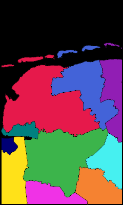
Size of this PNG preview of this SVG file: 240 × 400 pixels. Other resolution: 144 × 240 pixels.
Original file (SVG file, nominally 240 × 400 pixels, file size: 224 KB)
Summary
| Name | Geohash probability |
|---|---|
| ■ Landkreis Aurich | 17.3% |
| ■ Landkreis Leer | 14.2% |
| ■ Landkreis Wittmund | 9.0% |
| ■ Oost-Groningen | 5.8% |
| ■ Landkreis Cloppenburg | 5.1% |
| ■ Landkreis Friesland | 5.1% |
| ■ Landkreis Ammerland | 4.5% |
| ■ Landkreis Emsland | 3.9% |
| ■ Emden | 1.5% |
| ■ Delfzijl en omgeving | 0.82% |
| ■ Wilhelmshaven | 0.0021% |
Source: Kripakko's Graticule partitioner
File history
Click on a date/time to view the file as it appeared at that time.
| Date/Time | Thumbnail | Dimensions | User | Comment | |
|---|---|---|---|---|---|
| current | 17:07, 7 June 2024 |  | 240 × 400 (224 KB) | Fippe (talk | contribs) | {| class="wikitable" !Name!!Geohash<br />probability |- |<span style="color:#e6194b">■</span> Landkreis Aurich||17.3% |- |<span style="color:#3cb44b">■</span> Landkreis Leer||14.2% |- |<span style="color:#4363d8">■</span> Landkreis Wittmund||9.0%... |
- You cannot overwrite this file.
File usage
There are no pages that link to this file.