Difference between revisions of "1896-05-26 52 9"
imported>Fippe m (infobox) |
imported>Fippe (aerial view available in infobox) |
||
| Line 2: | Line 2: | ||
<table class="infobox" style="margin:0.5em; width:22em; text-align:center; float:right; border:1px solid #aaa; background:#f9f9f9;"> | <table class="infobox" style="margin:0.5em; width:22em; text-align:center; float:right; border:1px solid #aaa; background:#f9f9f9;"> | ||
| − | <tr><td>[[File:1896-05-26 52 09 05 Map.png|300px]]<br><br>Fri 26 May 1896 in [[52,9|Hannover]]: <br><b>52.5240543, 9.8340160</b><br>[https://osm.org/?mlat=52.5240543&mlon=9.8340160 | + | <tr><td>[[File:1896-05-26 52 09 05 Map.png|300px]]<br><br>[[Retrohash|Fri 26 May 1896]] in [[52,9|Hannover]]: <br><b>52.5240543, 9.8340160</b><br>[https://osm.org/?mlat=52.5240543&mlon=9.8340160 osm] [https://maps.google.com/?q=52.5240543,9.8340160 google]</td></tr></table> |
==Location== | ==Location== | ||
| Line 23: | Line 23: | ||
*<code>0.d58213752e58db41<sub>16</sub> = 0.83401605234971347776<sub>10</sub></code> | *<code>0.d58213752e58db41<sub>16</sub> = 0.83401605234971347776<sub>10</sub></code> | ||
*Destination: <code>52.52405439152443432826, 9.83401605234971347776</code> | *Destination: <code>52.52405439152443432826, 9.83401605234971347776</code> | ||
| − | |||
| − | |||
I plan to visit this retrohash on '''2015-05-27''', which is a day after the 219th anniversary of the first DJIA opening. | I plan to visit this retrohash on '''2015-05-27''', which is a day after the 219th anniversary of the first DJIA opening. | ||
Revision as of 09:23, 10 December 2018
 Fri 26 May 1896 in Hannover: 52.5240543, 9.8340160 osm google |
Location
The geohash is located on a field next to a forest near Burgwedel.
Participants
Plans
The Dow Jones Industrial Average did not always exist, so I wanted to reach the coordinates of the first possible geohash.
According to this “fact sheet” published by S&P, the DJIA was first calculated on 1896-05-26. It also states that it's “Base Value” was 40.94, which might be it's closing value on that date, but I think it was the opening, since it seems to be the first recorded value. Anyway, I did the following calculations:
$ echo -n 1896-05-26-40.94 | md5sum
86286db8ec312754d58213752e58db41  -
Note that the 30W Time Zone Rule rule does not apply here, because this is a retrohash.
0.86286db8ec31275416 = 0.52405439152443432826100.d58213752e58db4116 = 0.8340160523497134777610- Destination:
52.52405439152443432826, 9.83401605234971347776
I plan to visit this retrohash on 2015-05-27, which is a day after the 219th anniversary of the first DJIA opening.
Expedition
It worked out. I walked there by foot from the train station in Großburgwedel, which is a couple of kilometers, but it was worth it. The Geohash itself is located in a field of Barley.
Photos
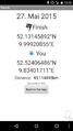
Proof that I am at the right spot for 1896-05-26, but far away from 2015-05-27
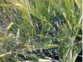
The Geohash
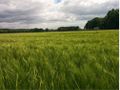
Landscape
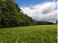
Landscape


Achievements
Fippe earned the Dow Day Achievement
|