Difference between revisions of "1955-11-28 49 8"
From Geohashing
imported>Q-Owl m (→Plans) |
imported>FippeBot m (Location) |
||
| (15 intermediate revisions by 2 users not shown) | |||
| Line 1: | Line 1: | ||
| − | + | [[Image:1955-11-28 49 8 grin.jpg|thumb|left|Happy grin]] | |
| − | |||
| − | [[Image: | ||
| − | |||
| − | |||
| − | |||
| − | |||
| − | |||
| − | |||
{{meetup graticule | {{meetup graticule | ||
| lat=49 | | lat=49 | ||
| Line 18: | Line 10: | ||
__NOTOC__ | __NOTOC__ | ||
== Location == | == Location == | ||
| − | Near Mainz, | + | Near [[wikipedia:Mainz|Mainz]], the capital of the state of Rhineland-Palatinate in Germany, next to an A65 highway exit. |
== Participants == | == Participants == | ||
| Line 24: | Line 16: | ||
== Plans == | == Plans == | ||
| − | This is my birthday hashpoint which I'm going to visit | + | 2013-10-14: This is my birthday hashpoint which I'm going to visit some day. I don't know when, nothing planned at the moment. ... ... |
| + | |||
| + | [[2015-11-18 49 8|2015-11-18]]: Today the current hashpoint is nearby (about 4 km). | ||
== Expedition == | == Expedition == | ||
| − | < | + | Success! <br>I took 2 h off, drove to the current hashpoint, drove to the birthday hashpoint, found a geocache (with nearly 100 favourite points) in the middle between both hashpoints and drove home. <br><nowiki>:-))</nowiki> |
| − | |||
| − | |||
| − | < | ||
== Photos == | == Photos == | ||
| Line 37: | Line 28: | ||
--> | --> | ||
<gallery perrow="5"> | <gallery perrow="5"> | ||
| + | Image:1955-11-28 49 8 proof.png | Proof | ||
| + | Image:1955-11-28 49 8 west.jpg | View west | ||
| + | Image:1955-11-28 49 8 south.jpg | View south | ||
| + | Image:1955-11-28 49 8 east.jpg | View east | ||
| + | Image:1955-11-28 49 8 grin.jpg | Happy grin | ||
</gallery> | </gallery> | ||
== Achievements == | == Achievements == | ||
| − | {{ | + | {{origin geohash |
| − | + | | latitude = 49 | |
| − | + | | longitude = 8 | |
| + | | date = 1955-11-28 | ||
| + | | on = 2015-11-18 | ||
| + | | name = Q-Owl | ||
| + | | image = 1955-11-28 49 8 grin.jpg | ||
| + | }} | ||
| + | No Multihash, because not on the <nowiki>'correct' day. *sigh* </nowiki>} | ||
| − | |||
| − | |||
| − | |||
| − | |||
| − | |||
| − | |||
| − | |||
| − | |||
| − | |||
| − | |||
| − | |||
[[Category:Expeditions with photos]] | [[Category:Expeditions with photos]] | ||
| − | [[Category: | + | [[Category:Retro coordinates reached]] |
| − | + | [[Category:Origin_reached]] | |
| − | + | {{location|DE|RP|MZ}} | |
| − | |||
| − | |||
| − | |||
| − | |||
| − | |||
| − | |||
| − | [[Category: | ||
| − | |||
| − | |||
| − | |||
| − | |||
| − | |||
| − | |||
| − | |||
| − | |||
| − | |||
| − | |||
| − | |||
| − | |||
| − | |||
| − | |||
Latest revision as of 09:36, 15 July 2019

| Mon 28 Nov 1955 in 49,8: 49.9476034, 8.2199497 geohashing.info google osm bing/os kml crox |
Location
Near Mainz, the capital of the state of Rhineland-Palatinate in Germany, next to an A65 highway exit.
Participants
Plans
2013-10-14: This is my birthday hashpoint which I'm going to visit some day. I don't know when, nothing planned at the moment. ... ...
2015-11-18: Today the current hashpoint is nearby (about 4 km).
Expedition
Success!
I took 2 h off, drove to the current hashpoint, drove to the birthday hashpoint, found a geocache (with nearly 100 favourite points) in the middle between both hashpoints and drove home.
:-))
Photos
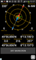
Proof
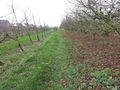
View west
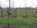
View south
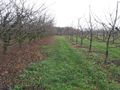
View east

Happy grin


Achievements
Q-Owl earned the Origin geohash achievement
|
No Multihash, because not on the 'correct' day. *sigh* }