Difference between revisions of "1966-12-01 59 18"
imported>Cjk ([retro picture] Panorama south) |
imported>FippeBot m (Location) |
||
| (4 intermediate revisions by 2 users not shown) | |||
| Line 1: | Line 1: | ||
| − | |||
<!-- If you did not specify these parameters in the template, please substitute appropriate values for IMAGE, LAT, LON, and DATE (YYYY-MM-DD format) | <!-- If you did not specify these parameters in the template, please substitute appropriate values for IMAGE, LAT, LON, and DATE (YYYY-MM-DD format) | ||
| Line 13: | Line 12: | ||
| lon=18 | | lon=18 | ||
| date=1966-12-01 | | date=1966-12-01 | ||
| + | | retro=1 | ||
}} | }} | ||
| Line 19: | Line 19: | ||
== Location == | == Location == | ||
<!-- where you've surveyed the hash to be --> | <!-- where you've surveyed the hash to be --> | ||
| + | Between the trees in the middle of Valhallavägen, just north of Fältöversten. | ||
== Participants == | == Participants == | ||
<!-- who attended --> | <!-- who attended --> | ||
| + | [[User:Cjk|Carl-Johan]] | ||
== Plans == | == Plans == | ||
<!-- what were the original plans --> | <!-- what were the original plans --> | ||
| + | To try out my new code for generating all [[Retro|Retro hashes]] around your position I decided to try as many as I could during three days. | ||
| + | |||
| + | First retro, day 1: | ||
| + | *[[1991-07-04 59 18]] | ||
| + | |||
| + | Day 2: | ||
| + | *[[1929-05-19 59 18]] | ||
| + | *[[1970-10-18 59 18]] | ||
| + | *[[1931-11-17 59 18]] | ||
| + | *[[1942-10-23 59 18]] | ||
| + | *[[1987-05-03 59 18]] | ||
| + | *[[1952-04-14 59 18]] | ||
| + | *[[1953-02-26 59 18]] | ||
| + | |||
| + | Day 3: | ||
| + | *[[2004-12-04 59 18]] | ||
| + | *[[2004-11-12 59 18]] | ||
| + | *[[1980-07-07 59 18]] | ||
| + | *[[1964-02-21 59 18]] | ||
| + | *[[1966-12-01 59 18]] | ||
| − | == Expedition == | + | == Retro Expedition 2012-02-09 == |
<!-- how it all turned out. your narrative goes here. --> | <!-- how it all turned out. your narrative goes here. --> | ||
| − | + | Walking from the last hash I saw some nice "Funkis" buildings. All of Gärdet looks like that era in houses, 1930s or something. | |
| − | + | ||
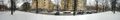
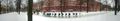
| + | The GPS got confused again by clouds, snow, trees and buildings, but it was easy to count trees in Google Maps and in real life so I found the spot fairly quickly. Snapped some panoramas and headed off to Vinylbutiken to buy a Shellac of North America record that I had ordered. Then off home to warm up a bit after my 6 hashes in the cold today. | ||
| + | |||
| + | [[Image:1966-12-01_59_18_14-47-10-054.jpg]] | ||
== Photos == | == Photos == | ||
| Line 52: | Line 77: | ||
<!-- =============== USEFUL CATEGORIES FOLLOW ================ | <!-- =============== USEFUL CATEGORIES FOLLOW ================ | ||
Delete the next line ONLY if you have chosen the appropriate categories below. If you are unsure, don't worry. People will read your report and help you with the classification. --> | Delete the next line ONLY if you have chosen the appropriate categories below. If you are unsure, don't worry. People will read your report and help you with the classification. --> | ||
| − | [[Category: | + | [[Category:Expeditions with photos]] |
| + | [[Category:Retro coordinates reached]] | ||
| + | |||
<!-- Potential categories. Please include all the ones appropriate to your expedition --> | <!-- Potential categories. Please include all the ones appropriate to your expedition --> | ||
| Line 79: | Line 106: | ||
[[Category:Not reached - Did not attempt]] when you went to an alternate location, or decided early on to abort the expedition. | [[Category:Not reached - Did not attempt]] when you went to an alternate location, or decided early on to abort the expedition. | ||
--> | --> | ||
| + | {{location|SE|AB}} | ||
Latest revision as of 03:46, 7 August 2019
| Thu 1 Dec 1966 in 59,18: 59.3406807, 18.0913135 geohashing.info google osm bing/os kml crox |
Location
Between the trees in the middle of Valhallavägen, just north of Fältöversten.
Participants
Plans
To try out my new code for generating all Retro hashes around your position I decided to try as many as I could during three days.
First retro, day 1:
Day 2:
- 1929-05-19 59 18
- 1970-10-18 59 18
- 1931-11-17 59 18
- 1942-10-23 59 18
- 1987-05-03 59 18
- 1952-04-14 59 18
- 1953-02-26 59 18
Day 3:
Retro Expedition 2012-02-09
Walking from the last hash I saw some nice "Funkis" buildings. All of Gärdet looks like that era in houses, 1930s or something.
The GPS got confused again by clouds, snow, trees and buildings, but it was easy to count trees in Google Maps and in real life so I found the spot fairly quickly. Snapped some panoramas and headed off to Vinylbutiken to buy a Shellac of North America record that I had ordered. Then off home to warm up a bit after my 6 hashes in the cold today.

Photos
Panorama north
Panorama south
