Difference between revisions of "2008-05-21 54 -2"
From Geohashing
imported>Nicktaylor |
imported>Nicktaylor |
||
| Line 1: | Line 1: | ||
| + | [[Image:Lancaster-uk-22-may-08-photo.jpg|thumb|240px]] | ||
| + | [[Image:Lancaster-uk-22-may-08.png|thumb|250px|Lancaster and Carlisle coordinates on 21st May 2008]] | ||
==About== | ==About== | ||
| − | |||
On [http://irc.peeron.com/xkcd/map/map.html?date=2008-05-21&lat=54&long=-3&zoom=9&abs=1 21st May 2008], the day the algorithm was published, the geohash for [[Carlisle / Lancaster, United Kingdom|Lancaster and Carlisle]] was a spot on the coast near Silverdale at 54.179467°, -2.861537°. | On [http://irc.peeron.com/xkcd/map/map.html?date=2008-05-21&lat=54&long=-3&zoom=9&abs=1 21st May 2008], the day the algorithm was published, the geohash for [[Carlisle / Lancaster, United Kingdom|Lancaster and Carlisle]] was a spot on the coast near Silverdale at 54.179467°, -2.861537°. | ||
| Line 7: | Line 8: | ||
Nick made a short video around 9pm, [http://youtube.com/watch?v=6Ty8pw1BbKE available here]. | Nick made a short video around 9pm, [http://youtube.com/watch?v=6Ty8pw1BbKE available here]. | ||
| − | |||
| − | |||
== People == | == People == | ||
[[User:Nicktaylor|Nicktaylor]] | [[User:Nicktaylor|Nicktaylor]] | ||
Revision as of 13:32, 22 May 2008
About
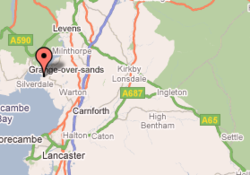
On 21st May 2008, the day the algorithm was published, the geohash for Lancaster and Carlisle was a spot on the coast near Silverdale at 54.179467°, -2.861537°.
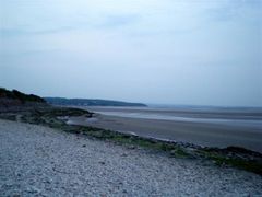
While Google maps shows this as being on land, it is actually in the treacherous sands of Morecambe Bay. The closest accessible location was a beach near small caravan park, visible on the aerial view.
Nick made a short video around 9pm, available here.

