Difference between revisions of "2008-05-22 40 -105"
From Geohashing
imported>Thomcat (Success/failure category added) |
imported>Thomcat (removed ribbon (sorry)) |
||
| Line 6: | Line 6: | ||
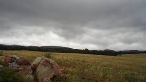
I left about 4pm after the weather calmed down - todays storm system left quite the mark on these dirt roads. The actual point itself is beyond the trees which reside on ''very'' private ranch property. The pile of rocks seemed like a good marker for any future visits. | I left about 4pm after the weather calmed down - todays storm system left quite the mark on these dirt roads. The actual point itself is beyond the trees which reside on ''very'' private ranch property. The pile of rocks seemed like a good marker for any future visits. | ||
| − | |||
| − | |||
| − | |||
| − | |||
| − | |||
| − | |||
| − | |||
| − | |||
{{No trespassing geohash | {{No trespassing geohash | ||
| latitude = 40 | | latitude = 40 | ||
Revision as of 01:26, 5 August 2008
[[Category:Meetup in {{{lat}}} {{{lon}}}| ]]
40.972874°, -105.238697 - User:The-r-gonaut
I left about 4pm after the weather calmed down - todays storm system left quite the mark on these dirt roads. The actual point itself is beyond the trees which reside on very private ranch property. The pile of rocks seemed like a good marker for any future visits.
The-r-gonaut earned the No trespassing consolation prize
|
