2008-05-24
From Geohashing
Revision as of 16:52, 23 May 2008 by imported>AceJohnny (added Grenoble, France)
May 24th, 2008 will be the first Saturday after the algorithm was published. The coordinates are:
0.1266480113970560, 0.5475331240942810
It will be a Saturday, so there will be an xkcd meetup at 4:00 PM in regions where they are reachable.
Coordinates
- 2008-05-24 in the Boston, MA graticule -- Coordinates are in Hopedale. The exact coordinates are in someone's house, so obviously they will not be reached within a foot, but they can expect some odd passers-by on their road.
- Graz, Austria Near Strallegg, eastern part of styria: 47.400246°, 15.722771°
- Austin, Texas, United States 30.1266480113970560,-97.5475331240942810 - Looks private, but perhaps accessible.
- 2008-05-24 in Baltimore, MD -- Coordinates are at a house on 229th st in Pasadena MD.
- Saskatoon, Sk - south at College and Highway 5, down ridge road 3045, just south of second farm on East side, middle of that field. Watch out for John Deeres as farmer maybe seeding!!
- Berlin, Germany Close to Erkner, reachable with public transport, on a field. Nice lakes around, worth a trip!
- Edinburgh, UK -- Coordinates are in a field, east of Amisfield.
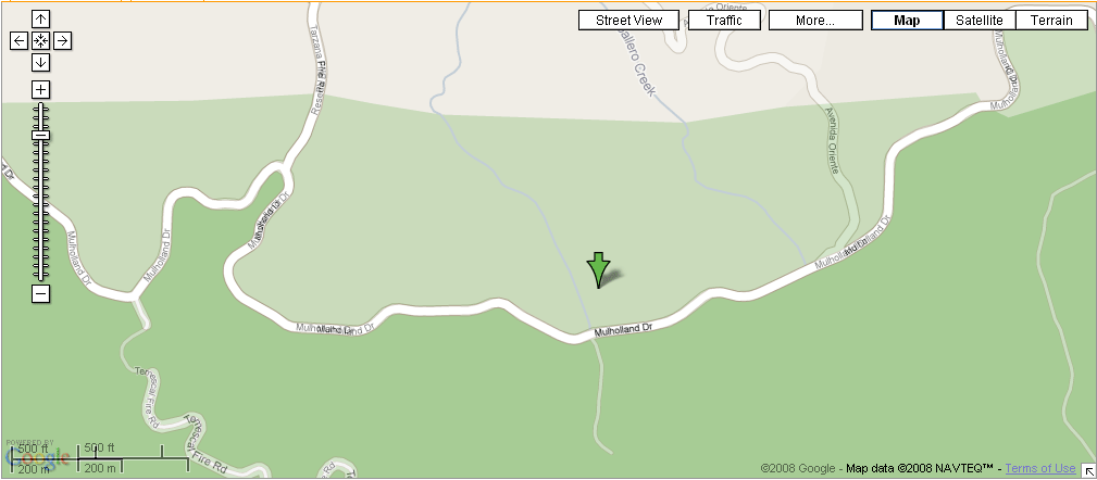
- Los Angeles, California -- Actually in West LA proper, and not too far from a Mulholland Drive in Topanga State Park. Note that in the park, Mulholland is a fire road and will probably be closed to vehicles. One should be able to hike/bike in from the park boundary, either on Mulholland Dr or perhaps on Reseda Blvd in Tarzana. There is a Nike missile silo nearby. Google Maps seems to exist in two different realities as to the geography of the area; see image for details.
- Trenton, New Jersey -- Out in the woods/pine barrens, looks doable: 40.126648°, -74.547534°
- Carlisle, United Kingdom -- A field that looks like it can be reached on foot from Lower Bentham: 54.126648°, -2.547534°
- Cincinnati, Ohio -- Seems to be a public road leading to a few private residences. Accessible. Bringing Twister.
- Schaumburg, IL -- Possibly accessible. Middle of some farm land north west of Route 20 and 72 intersections. I'd say meet on the north end of the point along Melms Road. 42.126648°, -88.547534°
- Inland Empire, CA -- Accessible. Near Vintage Park in Rancho Cucamonga.
- Sheffield, United Kingdom -- Amongst trees near some greenhouses. Might be private. Sharp bend in the Riber Road due West seems like a possible meeting place.
- London, United Kingdom -- In some woods off the A281 near Cranleigh in Surrey. Looks like there's a path going right to it! (51.1266480113970560,-0.5475331240942810)
- Grenoble, France -- Accessible. In the forest in the Vercors Mountains. Went hiking in the area recently :) About 45mins by car from Grenoble. (45.126648°, 5.547533°) [1].