Difference between revisions of "2008-05-24 40 -105"
From Geohashing
imported>Jeffhutch103 |
imported>Jeffhutch103 |
||
| Line 14: | Line 14: | ||
We left the parking lot meeting place at about 4:10pm and made our way up the trail. We met up with some other geohashers that were coming down from the geohash point. Half of them joined us to return to the point. While at the location, we played Twister, chess, built miniature snowmen as markers and took a group photo. | We left the parking lot meeting place at about 4:10pm and made our way up the trail. We met up with some other geohashers that were coming down from the geohash point. Half of them joined us to return to the point. While at the location, we played Twister, chess, built miniature snowmen as markers and took a group photo. | ||
| − | Geohashers that made it: ( | + | Geohashers that made it: (11 total)<br> |
[[User:Jeffhutch103|Jeff]]<br> | [[User:Jeffhutch103|Jeff]]<br> | ||
Michael<br> | Michael<br> | ||
Revision as of 06:53, 25 May 2008
| Sat 24 May 2008 in 40,-105: 40.1266480, -105.5475331 geohashing.info google osm bing/os kml crox |
40.126648°,-105.547534°
The NW Denver coordinates were reached by many people. It was in the Arapaho National Forest at an altitude of 9,610 feet. Snow made the trail difficult to navigate.
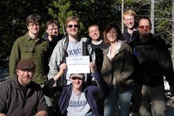
We left the parking lot meeting place at about 4:10pm and made our way up the trail. We met up with some other geohashers that were coming down from the geohash point. Half of them joined us to return to the point. While at the location, we played Twister, chess, built miniature snowmen as markers and took a group photo.
Geohashers that made it: (11 total)
Jeff
Michael
Mario
Doug
Jaeger
Mike
Celeste
Pictures:
Jeff's Pictures 5-24-08
