Difference between revisions of "2008-05-24 42 -76"
imported>Ccccc m (Prettier image boxes) |
imported>Ccccc |
||
| Line 16: | Line 16: | ||
Image:2008-05-24 42 -76 Rock Climbers.JPG|Two of our team trying to show the scale of the rock face that would need to be climbed. | Image:2008-05-24 42 -76 Rock Climbers.JPG|Two of our team trying to show the scale of the rock face that would need to be climbed. | ||
Image:2008-05-24 42 -76 Rock Face.JPG|Another nice view of the unfortunate (but beautiful!) terrain. | Image:2008-05-24 42 -76 Rock Face.JPG|Another nice view of the unfortunate (but beautiful!) terrain. | ||
| + | Image:2008-05-24 42 -76 Location.JPG|[http://www.empirestateroads.com/rm/ A non-GPS way to prove locations on NY Highways]. We were 8.4 miles north of Pennsylvania, on Rt 34. | ||
</gallery> | </gallery> | ||
Revision as of 07:34, 25 May 2008
| Sat 24 May 2008 in 42,-76: 42.1266480, -76.5475331 geohashing.info google osm bing/os kml crox |
Reached (sort of) by Chris and Co. Didn't have GPS, but since there was a cliff between the highway and the destination, it seems likely that most people would have chosen to hang out beside the highway anyway.
We parked and waited for about 10-15 minutes, but saw evidence that some impatient people had pulled over in the same spot not long before, so we took pictures and headed back.
Another user (67.241.37.137) also claimed to reach the location at approximately 4:15pm. Apparently our graticule lacks patience!
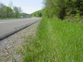
Evidence that another car had pulled over in this spot not long ago...
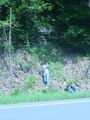
Two of our team trying to show the scale of the rock face that would need to be climbed.
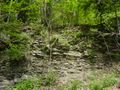
Another nice view of the unfortunate (but beautiful!) terrain.
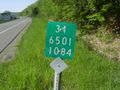
A non-GPS way to prove locations on NY Highways. We were 8.4 miles north of Pennsylvania, on Rt 34.


