Difference between revisions of "2008-05-24 52 4"
From Geohashing
imported>Pijll |
imported>Polysylabic Pseudonym (Categorising.) |
||
| Line 21: | Line 21: | ||
<small>(Actually, according to Google Maps, the proper spot was a bit more to the south, left of the fence in the picture. Oh well.)</small> | <small>(Actually, according to Google Maps, the proper spot was a bit more to the south, left of the fence in the picture. Oh well.)</small> | ||
| + | |||
| + | |||
| + | [[Category:Expeditions]] | ||
| + | [[Category:Expeditions with photos]] | ||
Revision as of 05:17, 27 May 2008
| Sat 24 May 2008 in 52,4: 52.1266480, 4.5475331 geohashing.info google osm bing/os kml crox |
The first meetup in Noord West Nederland was located near Hazerswoude. Four people and a larger number of cows showed up.
It was a beautiful day for cycling; four of us made the journey, separately and without communicating beforehand. I was a bit surprised that there were actually other people there.
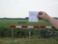
The spot was conveniently signposted.
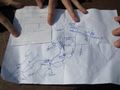
According to our handy maps, ...
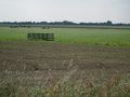
it was in the grassland just behind the fence.
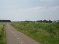
Immediate surroundings: cycling paths, a motorway, a windmill, a railroad, ...
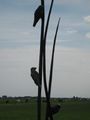
public art, ...
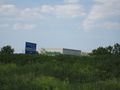
local industry.
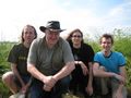
The participants of the meetup. Pijll at the right.


(Actually, according to Google Maps, the proper spot was a bit more to the south, left of the fence in the picture. Oh well.)