Difference between revisions of "2008-06-05 42 -70"
imported>Cogit0 |
imported>Cogit0 (added location details and pics) |
||
| Line 12: | Line 12: | ||
[http://maps.google.com/maps?f=q&hl=en&geocode=&q=42.066439%C2%B0,+-70.18439%C2%B0&ie=UTF8&ll=42.070959,-70.179462&spn=0.076329,0.11776&z=13&iwloc=addr Google maps location]<br> | [http://maps.google.com/maps?f=q&hl=en&geocode=&q=42.066439%C2%B0,+-70.18439%C2%B0&ie=UTF8&ll=42.070959,-70.179462&spn=0.076329,0.11776&z=13&iwloc=addr Google maps location]<br> | ||
[http://irc.peeron.com/xkcd/map/map.html?date=2008-06-05&lat=42&long=-70&zoom=15&abs=-1 xkcd map location]<br> | [http://irc.peeron.com/xkcd/map/map.html?date=2008-06-05&lat=42&long=-70&zoom=15&abs=-1 xkcd map location]<br> | ||
| − | |||
| + | This hash was reached, but on the incorrect day (Saturday instead of Thursday). The location was on top of a small ridge, a bit off of a small sandy trail that cut through the Cape Cod National Seashore just north of Provincetown. We rode our bikes out to the trailhead, and hiked in from there. Unfortunately, we had no way of confirming the location other than google earth on a laptop. | ||
| + | |||
| + | We arrived at the location with the intent to have some lobster at the location, but there were just too many mosquitoes. We took pics and bailed. | ||
| + | |||
| + | We're sad that we weren't able to make it on the correct day, but seeing that the following two days were well out of the way, this isn't either of our home graticules, and the odds of the hash landing where it did are near phenomenal, we decided it was well worth the effort to go out. | ||
== Plans == | == Plans == | ||
| − | [[User:Cogit0|cogit0]] and civet are planning on camping there this weekend, so will stop by and make a visit to the very rare land-hash in this graticule. | + | [[User:Cogit0|cogit0]] and civet are planning on camping there this weekend, so will stop by and make a visit to the very rare land-hash in this graticule.<br> |
| + | |||
| + | ==Who Went== | ||
| + | [[User:Cogit0|cogit0]]<br> | ||
| + | civet | ||
| + | |||
| + | ==Pics== | ||
| + | <gallery caption="North of Provincetown" widths="300px" heights="200px" perrow="2"> | ||
| + | Image:Lynn_2008-06-07-1.jpg|civet and a lobster we were going to eat at the spot.<br> 2008-06-07 42 -70, Provincetown, MA | ||
| + | Image:Lynn_2008-06-07-2.jpg|cogit0 and civet trying to not get eaten alive by the mosquitos<br> 2008-06-07 42 -70, Provincetown, MA | ||
| + | </gallery> | ||
| + | <BR> | ||
| + | |||
| + | [[Category:Expeditions with photos]] | ||
| + | [[Category:Expeditions]] | ||
Revision as of 18:31, 9 June 2008
| Thu 5 Jun 2008 in 42,-70: 42.0664391, -70.1843892 geohashing.info google osm bing/os kml crox |
Contents
Location
Inside the Cape Cod National Seashore, 1/4 mile north of Provincetown MA, 200 ft south of Grassy Pond, and on the southern shore of a small unnamed pond.
Coordinates: 42.066439°, -70.18439°
Google maps location
xkcd map location
This hash was reached, but on the incorrect day (Saturday instead of Thursday). The location was on top of a small ridge, a bit off of a small sandy trail that cut through the Cape Cod National Seashore just north of Provincetown. We rode our bikes out to the trailhead, and hiked in from there. Unfortunately, we had no way of confirming the location other than google earth on a laptop.
We arrived at the location with the intent to have some lobster at the location, but there were just too many mosquitoes. We took pics and bailed.
We're sad that we weren't able to make it on the correct day, but seeing that the following two days were well out of the way, this isn't either of our home graticules, and the odds of the hash landing where it did are near phenomenal, we decided it was well worth the effort to go out.
Plans
cogit0 and civet are planning on camping there this weekend, so will stop by and make a visit to the very rare land-hash in this graticule.
Who Went
cogit0
civet
Pics
- North of Provincetown
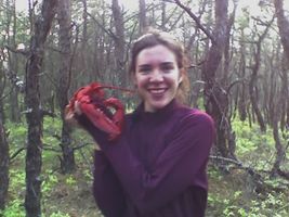
civet and a lobster we were going to eat at the spot.
2008-06-07 42 -70, Provincetown, MA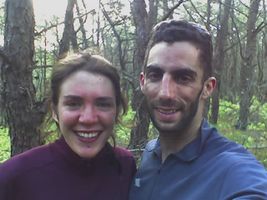
cogit0 and civet trying to not get eaten alive by the mosquitos
2008-06-07 42 -70, Provincetown, MA

