Difference between revisions of "2008-06-12 50 16"
From Geohashing
imported>Thomcat (Success/failure category added) |
imported>FippeBot m (Location) |
||
| (2 intermediate revisions by 2 users not shown) | |||
| Line 3: | Line 3: | ||
| lat=50 | | lat=50 | ||
| lon=16 | | lon=16 | ||
| − | | date=2008- | + | | date=2008-06-12 |
| graticule_name=Wałbrzych | | graticule_name=Wałbrzych | ||
| graticule_link=Wałbrzych, Poland | | graticule_link=Wałbrzych, Poland | ||
| Line 28: | Line 28: | ||
[[Category:Expeditions with photos]] | [[Category:Expeditions with photos]] | ||
[[Category:Coordinates not reached]] | [[Category:Coordinates not reached]] | ||
| − | [[Category: | + | [[Category:Not reached - No public access]] |
| + | {{location|PL|D|B}} | ||
Latest revision as of 00:00, 6 August 2019
| Thu 12 Jun 2008 in Wałbrzych: 50.7906706, 16.3355328 geohashing.info google osm bing/os kml crox |
Contents
About
The place is located in some meadow in Poniatów, a district of Wałbrzych.
Expeditions
Jajcuś
For me, it was a 6 kilometers walk from Szczawno-Zdrój via an unknown terrain and unknown city. I did not reach the point exactly, as it seemed I would have to walk through someone's field or garden. And I wanted to catch a bus which was to depart soon. I missed the exact site by about 300m.
Pictures
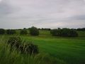
The point is somewhere between those trees.
