Difference between revisions of "2008-06-20 -34 139"
From Geohashing
imported>Karcean (→Photos) |
imported>Karcean (→Photos) |
||
| Line 18: | Line 18: | ||
Image:20080620 -34 139 4.JPG|Half way there i filled up at Gumeracha | Image:20080620 -34 139 4.JPG|Half way there i filled up at Gumeracha | ||
Image:20080620_-34_139_5.jpg|The last of our light at our destination | Image:20080620_-34_139_5.jpg|The last of our light at our destination | ||
| − | Image: | + | Image:20080620 -34 139 6.JPG|GPS proof |
</gallery> | </gallery> | ||
[[Category:Expeditions]] | [[Category:Expeditions]] | ||
[[Category:Expeditions with photos]] | [[Category:Expeditions with photos]] | ||
Revision as of 05:50, 21 June 2008
| Fri 20 Jun 2008 in -34,139: -34.8812831, 139.0866544 geohashing.info google osm bing/os kml crox |
About
Friday's geohash for north eastern Adelaide was out past Lobethal somewhere near a place called Tungkillo.
And in the failing light we completed the Geo#
People
- Nathan and BobTheFish got there around 5:30pm
Photos
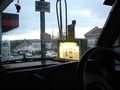
Half way there i filled up at Gumeracha
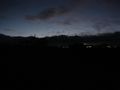
The last of our light at our destination
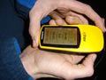
GPS proof


