Difference between revisions of "2008-06-21 60 -149"
From Geohashing
imported>Nutsenmai (→Execution/Aftermath) |
imported>Nutsenmai (→Photographic Evidence: add photos) |
||
| Line 25: | Line 25: | ||
== Photographic Evidence == | == Photographic Evidence == | ||
| + | |||
| + | <gallery caption="Orbatos, Nutsenmai, Yos and Nycti's Saturday Expedition" widths="150px" heights="100px" perrow="3"> | ||
| + | Image:2008-06-21_sev.jpg|[[user:Orbatos|Orbatos]] at our alternate location. The graticule is somewhere behind him. | ||
| + | Image:2008-06-21_lin.jpg|[[User:nutsenmai|Nutsenmai]] complete with [http://www.glarkware.com/productcart/pc/msg.asp?message=83 cute hammie shirt] | ||
| + | Image:2008-06-21_linmin.jpg|[[User:nutsenmai|Nutsenmai]] making sure [[user:nycti|Nycti]] gets in on the action. She slept through the trip there. | ||
| + | Image:2008-06-21_view1.jpg|Turnagain Arm | ||
| + | Image:2008-06-21_view2.jpg|The graticule, about half a kilometer out there in the water. | ||
| + | Image:2008-06-21_view3.jpg|There were lots of neat jet trails that day. | ||
| + | </gallery> | ||
Revision as of 08:22, 23 June 2008
| Sat 21 Jun 2008 in Seward, AK: 60.9793177, -149.6139621 geohashing.info google osm bing/os kml crox |
Logistics
- A bit out of the way, yet still attainable Saturday meetup out on the Turnagain Arm.
- An alternate location in a pullout 656 meters from the actual point in the inlet has been designated.
- About a 25 minute drive from midtown Anchorage.
Intended Attendees
- Orbatos, Nutsenmai, and Nycti are planning on stopping by at some point after 4pm.
- Yos has a wedding to attend and sadly will not be able to make it.
Execution/Aftermath
- Orbatos, Nutsenmai, and Nycti's GPS was only able to connect to one satellite, and we didn't print out a map, so we had to go off of memory to find the correct pullout. After a couple stops, including Beluga Point, we found one we thought matched up fairly well just after the mile 107 signpost. Took a few pictures and were on our way back home.
- Confirmed the location as being the correct one upon our arrival home by referencing satellite maps and our recorded drive data.
Photographic Evidence
- Orbatos, Nutsenmai, Yos and Nycti's Saturday Expedition
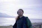
Orbatos at our alternate location. The graticule is somewhere behind him.

Nutsenmai complete with cute hammie shirt
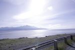
Turnagain Arm
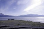
The graticule, about half a kilometer out there in the water.
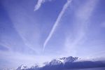
There were lots of neat jet trails that day.


