Difference between revisions of "2008-06-25 64 25"
imported>Oherrala m |
imported>Oherrala |
||
| Line 28: | Line 28: | ||
= Awards = | = Awards = | ||
| − | As of writing this we should have the [[North Geohash]] award. | + | As of writing this we should have the [[North Geohash]] award. |
| + | |||
| + | = Photos = | ||
| + | |||
| + | <gallery caption="Pictures" widths="200px" heights="200px" perrow="3"> | ||
| + | Image:2008-06-25_64_25_proof1.jpg|Otter with cool t-shirt and [[Oherrala]] holding the paper. | ||
| + | Image:2008-06-25_64_25_proof2.jpg|The paper and Tomtom showing the coordinates. | ||
| + | </gallery> | ||
Revision as of 20:53, 25 June 2008
| Wed 25 Jun 2008 in 64,25: 64.9125900, 25.7476571 geohashing.info google osm bing/os kml crox |
Located in the southeast of Oulu, Finland.
Contents
Story
And so the hash landed pretty close to our homes (near University of Oulu). Expedition was planned at morning and we closely monitored the weather for the whole day. Cladly it didn't rain when we started our trip around 20:30 local time (17:30 UTC).
The hash was in deep forest around 100 meters from nearest gravel road. We saw one Brown Hare (Lepus europaeus), heard Cuckoo (Cuculus canorus) sing and met batallions of finnish air forces (mosquitos).
Tomtom car navigator is not the best device to use when trying to reach accurate coordinates. The device updated coordinates after moving long enough distance with high enough speed. It must have been funny sight to see me (Oherrala) hopping around the forest with my navigator. For the next trip I need to get a compass.
After successfully reaching the geohash we headed towards geocache GC18ERA which we found.
Then we turned the car back to home and got welcomed by rain. We had good luck.
Participants
- Oherrala
- Otter
Awards
As of writing this we should have the North Geohash award.
Photos
- Pictures
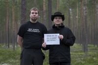
Otter with cool t-shirt and Oherrala holding the paper.
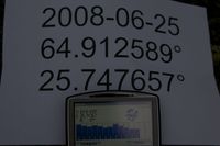
The paper and Tomtom showing the coordinates.

