Difference between revisions of "2008-06-28 37 -122"
From Geohashing
imported>Cwolves |
imported>Peter Kaminski (Added GPS-measured location, link to my Flickr set.) |
||
| Line 13: | Line 13: | ||
The official coordinates resolve to 37.65811°, -122.365635°, which is in the bay about 1km from the nearest land. | The official coordinates resolve to 37.65811°, -122.365635°, which is in the bay about 1km from the nearest land. | ||
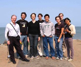
| − | + | Nine non-water 'hashers met on the nearest dry land, which is a small spit that juts out into the bay from Point San Bruno Park. At 4pm, we were at 37.65502°, -122.37578°. | |
| − | + | We moved to a nearby picnic table and played "Who Killed Dr. Lucky?" | |
| − | |||
| − | |||
In case you can't edit wikis, there's a [http://groups.google.com/group/sfsj-geohash mailing list] for the SF/SJ graticules. If you want to subscribe by email, send a blank email to sfsj-geohash-subscribe@googlegroups.com | In case you can't edit wikis, there's a [http://groups.google.com/group/sfsj-geohash mailing list] for the SF/SJ graticules. If you want to subscribe by email, send a blank email to sfsj-geohash-subscribe@googlegroups.com | ||
| − | |||
| − | |||
| − | |||
| − | |||
| − | |||
| − | |||
| − | |||
| − | |||
| − | |||
| − | |||
== People == | == People == | ||
| − | People who | + | People who attended: |
==== 4pm PDT ==== | ==== 4pm PDT ==== | ||
| Line 47: | Line 35: | ||
[http://www.flickr.com/photos/cwolves/sets/72157605873171743/ CWolves' Flickr Photos] | [http://www.flickr.com/photos/cwolves/sets/72157605873171743/ CWolves' Flickr Photos] | ||
| + | |||
| + | [http://www.flickr.com/photos/peterkaminski/sets/72157605880095854/ Peter Kaminski's Flickr Photos] | ||
[[Image:6-28-08.jpg|thumb|320 px|[[2008-06-28|2008-06-28]]]] | [[Image:6-28-08.jpg|thumb|320 px|[[2008-06-28|2008-06-28]]]] | ||
Revision as of 18:22, 29 June 2008
| Sat 28 Jun 2008 in San Francisco: 37.6581110, -122.3656342 geohashing.info google osm bing/os kml crox |
Contents
About
These coordinates are located in the San Francisco, California graticule on 2008-06-28, near San Francisco International Airport.
The official coordinates resolve to 37.65811°, -122.365635°, which is in the bay about 1km from the nearest land.
Nine non-water 'hashers met on the nearest dry land, which is a small spit that juts out into the bay from Point San Bruno Park. At 4pm, we were at 37.65502°, -122.37578°.
We moved to a nearby picnic table and played "Who Killed Dr. Lucky?"
In case you can't edit wikis, there's a mailing list for the SF/SJ graticules. If you want to subscribe by email, send a blank email to sfsj-geohash-subscribe@googlegroups.com
People
People who attended:
