Difference between revisions of "2008-07-19 40 -87"
From Geohashing
imported>Brettdaniel |
imported>FippeBot m (Location) |
||
| (5 intermediate revisions by 4 users not shown) | |||
| Line 6: | Line 6: | ||
}} | }} | ||
| − | [[Category: Meetup in 40 - | + | The day's coordinates fell near Fithian, Illinois, about halfway between [[Champaign/Urbana, Illinois]] and [[Danville, Illinois]]. |
| + | |||
| + | [[user:brettdaniel | Brett]] stopped next to the soybean field containing the coordinates. He did not stay long since the road, US Route 150, was relatively busy and did not have much of a shoulder. | ||
| + | |||
| + | <gallery> | ||
| + | Image:2008-07-19 40 -87 gps.jpg | Brett's GPS showing his approach to the coordinates | ||
| + | Image:2008-07-19 40 -87 road and field.jpg | US Route 150, Fithian, Illinois, and the soybean field containing the coordinates | ||
| + | </gallery> | ||
| + | |||
| + | [[Category:Meetup in 40 -87]] | ||
| + | [[Category:Expeditions]] | ||
| + | [[Category:Expeditions with photos]] | ||
| + | [[Category:Coordinates not reached]] | ||
| + | [[Category:Not reached - No public access]] | ||
| + | {{location|US|IL|VE}} | ||
Latest revision as of 06:00, 7 August 2019
| Sat 19 Jul 2008 in 40,-87: 40.1094031, -87.8876392 geohashing.info google osm bing/os kml crox |
The day's coordinates fell near Fithian, Illinois, about halfway between Champaign/Urbana, Illinois and Danville, Illinois.
Brett stopped next to the soybean field containing the coordinates. He did not stay long since the road, US Route 150, was relatively busy and did not have much of a shoulder.
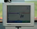
Brett's GPS showing his approach to the coordinates
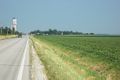
US Route 150, Fithian, Illinois, and the soybean field containing the coordinates

