Difference between revisions of "2008-09-01 -33 151"
imported>Shady (→Photos) |
imported>Thomcat (Success/failure category added) |
||
| Line 31: | Line 31: | ||
Image:Shady-1.jpg|As close as I could get. | Image:Shady-1.jpg|As close as I could get. | ||
</gallery> | </gallery> | ||
| + | |||
| + | [[Category:Expeditions]] | ||
| + | [[Category:Expeditions with photos]] | ||
| + | [[Category:Coordinates not reached]] | ||
| + | [[Category:Failed - Mother Nature]] | ||
Revision as of 17:23, 29 September 2008
| Mon 1 Sep 2008 in -33,151: -33.6360098, 151.0640611 geohashing.info google osm bing/os kml crox |
Contents
Location
This hash point was in bush land, slightly West off the end of Mansfield Rd, Arcadia.
Attendees
Report
This geohash looked like it would be a quick and easy afternoon hash. I had to be in nearby Dural in the evening anyway, so figured I could take a slight detour and visit the hash point on my way there.
I arrived at the end of Mansfield Rd about 5:45, just after the sun had set and as the light was fading. My plan was to head directly North into the bush before heading West to the hash point, in order to avoid going along the edge of houses. Upon heading into the bush, I quickly came across a deep valley that I would need to descend into then walk along in order to reach the hash point. This may have been possible had I got there earlier, however due to time constraints and the fact that it was now dark I decided that it would not be possible.
Photos
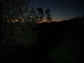
The hash point is just there.... somewhere.
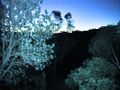
And this time with light.

As close as I could get.


