Difference between revisions of "2008-09-17 36 -76"
imported>FippeBot m (Location) |
m |
||
| Line 24: | Line 24: | ||
[[Category:Expeditions with photos]] | [[Category:Expeditions with photos]] | ||
[[Category:Coordinates not reached]] | [[Category:Coordinates not reached]] | ||
| + | [[Category:Not reached - No public access]] | ||
{{location|US|VA|SO}} | {{location|US|VA|SO}} | ||
Latest revision as of 20:56, 30 May 2022
| Wed 17 Sep 2008 in Norfolk, VA: 36.7278133, -76.7221626 geohashing.info google osm bing/os kml crox |
About
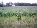
Hashpoint fell several yards into the frontage of a lush soybean field in Suffolk.
Expeditions
Involute, still deeply enthralled by a new GPS doohicky, tried to reach a nearby hashpoint. Driving the lovely twisty backroads I don't get to see too often, I considered it therapy after a mind-numbing daylong presentation/meeting at work. Sheesh, who'd have thought librarians could be boring?
The closest place to park was in front of a small abandoned house quite near the roadside. Sadly, the field glimpsed on Google maps which I had hoped would be given over to easily navigable corn or, better yet, already harvested was sporting a healthy growth of soybeans. As wading in would have been impossible without causing a swath of protein-rich destruction, I made the awkward leaning reach over the field to try to photograph my closest approach. I'm sure those people who drove past at that moment were laughing with me.
Photos
The site
Arg! thwarted by agricultural respect

Goofy grin
.jpg)
.jpg)
.jpg)