Difference between revisions of "2008-10-18 35 -107"
imported>Bishop Wash m (Added attempted Albuquerque geohash.) |
imported>ReletBot m (Failed => Not reached) |
||
| Line 22: | Line 22: | ||
[[Category:Expeditions with photos]] | [[Category:Expeditions with photos]] | ||
[[Category:Coordinates not reached]] | [[Category:Coordinates not reached]] | ||
| − | [[Category: | + | [[Category:Not reached - No public access]] |
Revision as of 20:32, 31 March 2009
| Sat 18 Oct 2008 in 35,-107: 35.0236881, -107.3062578 geohashing.info google osm bing/os kml crox |
Expedition
Bishop_Wash: Today's coordinates were in a place where I thought I could complete a hash in the Grants, New Mexico graticule and were relatively close to home. Google maps said it was 38 miles away, so I left home around 1515 to make it there by 1600. After exiting I-40, I entered the Laguna Reservation and encountered a sign asking that no pictures be taken. It didn't mention no trespassing, so I continued on. Once I reached the railroad tracks, as seen on the map, there was a fence with no trespassing signs. I checked the GPS and was .3 miles from the geohash. Couldn't get the virgin graticule achievement today. Someday soon I hope to get it.
On the drive back to Albuquerque I stopped along side the road and took a picture of the mesa. The geohash is somewhere along the base. I also decided to attempt the Albuquerque geohash.
Pictures
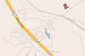
Google map of today's geohash
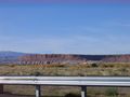
The geohash is somewhere at the base of the mesa

