Difference between revisions of "2008-10-21 53 -2"
imported>Styles (New page: {{meetup graticule | map=<map lat="53" lon="-2" date="2008-10-21" /> | lat=53 | lon=-2 | date=2008-10-21 | graticule_name=Manchester | graticule_link=Manchester, United Kingdom}} == About...) |
imported>FippeBot m (Location) |
||
| (6 intermediate revisions by 3 users not shown) | |||
| Line 20: | Line 20: | ||
An early afternoon experdition with one of my friends, we parked on a nearby housing estate. and using a public footpath gained access to the canal. We walked down the canal, towards the bridge. When we arrived at the bridge there was no access up to it. We walked down a bit further and found access onto the field on our side of the canal. However, as we approached the bridge, the ground became very muddy and I almost lost a trainer. We headed back onto the canal. As we came off the towpath we noted another nearby bridge, which the footpath from the housing estate lead up to. We walked up here, however we were greated with the "No Public access". So were unable to reach the geohash. | An early afternoon experdition with one of my friends, we parked on a nearby housing estate. and using a public footpath gained access to the canal. We walked down the canal, towards the bridge. When we arrived at the bridge there was no access up to it. We walked down a bit further and found access onto the field on our side of the canal. However, as we approached the bridge, the ground became very muddy and I almost lost a trainer. We headed back onto the canal. As we came off the towpath we noted another nearby bridge, which the footpath from the housing estate lead up to. We walked up here, however we were greated with the "No Public access". So were unable to reach the geohash. | ||
| + | ==Photos== | ||
| + | <gallery perrow="4"> | ||
| + | Image:2008_10_21_53_-2_canal_side.jpg|It was a nice day. | ||
| + | Image:2008_10_21_53_-2_muddy.jpg|The ground wasn't as hard as I thought. | ||
| + | Image:2008_10_21_53_-2_muddy_trainer.jpg|Resulting mess of my trainers, next time boots. | ||
| + | Image:2008_10_21_53_-2_no_access.jpg|Our geohash brought to an abrupt end. | ||
| + | </gallery> | ||
| − | + | <!-- not without trying --> | |
| + | |||
[[Category:Expeditions]] | [[Category:Expeditions]] | ||
| − | [[Category:Coordinates not reached]] | + | [[Category:Coordinates not reached]] |
| − | [[Category: | + | [[Category:Not reached - No public access]] |
[[Category:Meetup on 2008-10-21]] | [[Category:Meetup on 2008-10-21]] | ||
[[Category:Meetup in 53 -2]] | [[Category:Meetup in 53 -2]] | ||
| + | {{location|GB|ENG|CHE}} | ||
Latest revision as of 00:29, 8 August 2019
| Tue 21 Oct 2008 in Manchester: 53.1782010, -2.1805686 geohashing.info google osm bing/os kml crox |
About
Yet another middle-of-the-field geohash, for our graticule, just off the A54 outside congleton.
Planned Expeditions
Styles
After looking at the aerial images from google, there didn't seem like a easy way to get to it from the main road. However, there was a canal nearby with a bridge over it, to an adjacent field where the geohash was. So, access permitting we may be able to reach the geohash.
Expeditions
Styles
An early afternoon experdition with one of my friends, we parked on a nearby housing estate. and using a public footpath gained access to the canal. We walked down the canal, towards the bridge. When we arrived at the bridge there was no access up to it. We walked down a bit further and found access onto the field on our side of the canal. However, as we approached the bridge, the ground became very muddy and I almost lost a trainer. We headed back onto the canal. As we came off the towpath we noted another nearby bridge, which the footpath from the housing estate lead up to. We walked up here, however we were greated with the "No Public access". So were unable to reach the geohash.
Photos
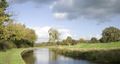
It was a nice day.
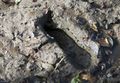
The ground wasn't as hard as I thought.
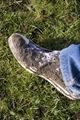
Resulting mess of my trainers, next time boots.
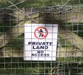
Our geohash brought to an abrupt end.


