Difference between revisions of "2008-10-31 41 -96"
imported>Relet m (2008 10 31 41 -96 moved to 2008-10-31 41 -96: +dashes) |
imported>ReletBot m (Failed => Not reached) |
||
| Line 30: | Line 30: | ||
Image:2008_10_31_41_-96_HumanMark.JPG|...and ourselves! | Image:2008_10_31_41_-96_HumanMark.JPG|...and ourselves! | ||
</gallery> | </gallery> | ||
| − | |||
[[Category:Expeditions]] | [[Category:Expeditions]] | ||
[[Category:Expeditions with photos]] | [[Category:Expeditions with photos]] | ||
[[Category:Coordinates not reached]] | [[Category:Coordinates not reached]] | ||
| − | [[Category: | + | [[Category:Not reached - No public access]] |
Revision as of 20:32, 31 March 2009
| Fri 31 Oct 2008 in Omaha (West): 41.1274886, -96.4908716 geohashing.info google osm bing/os kml crox |
Contents
About
The hash was located in a cornfield somewhere near Ithaca, NE. (Apologies for the very late upload, this was a while ago.)
Expeditions
Piratji21
Around 3:30 CST, my friends and I headed out from the city with a car, a set of directions we consulted from time to time, a camera and a GPS device. After taking one of the major highways out of the city and haphazardly navigating the country roads in the country, we arrived at a spot near the hashpoint. We arrived at around 4:40, and because the actual point was in a cornfield on private property, we though that it would be best to just explore the area and poke around. After taking a small walk down a road we parked next to, we came upon a house that had very large dogs that began to observe us once we came near the house, after which we turned back toward the car and headed to a park at around
Gallery
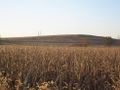
One view of where the hashpoint was.
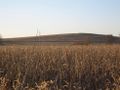
Another view of the hashpoint.
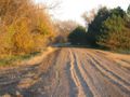
Dead end road leading up to the house.
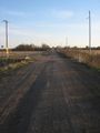
The road we stopped on.
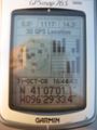
Proof of the expedition.
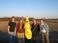
Photo of the group.
Leaving our mark with sticks...
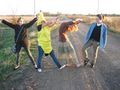
...and ourselves!


