Difference between revisions of "2009-01-25 32 -111"
From Geohashing
imported>Wyle & RoadRunner (New page: {{meetup graticule | map=<map lat="32" lon="-111" date="2009-01-25" /> | lat=32 | lon=-111 | date=2009-01-25 | graticule_name=Casa Grande | graticule_link=Casa Grande, Arizona}} == Expedit...) |
imported>Wyle & RoadRunner |
||
| Line 9: | Line 9: | ||
Location was about 1/4 mile within the Tohono O'odham Indian Reservation which does not allow off road tresspassing. While we were estimating the location from a pullout on the highway, agents of the US Border Patrol stopped to "make sure we weren't doing something that would get us in trouble". Taking pictures was the quick answer since we didn't want to try to explain geohashing (probably at the local substation). We opted for a 2 mile hike at a nearby trailhead. | Location was about 1/4 mile within the Tohono O'odham Indian Reservation which does not allow off road tresspassing. While we were estimating the location from a pullout on the highway, agents of the US Border Patrol stopped to "make sure we weren't doing something that would get us in trouble". Taking pictures was the quick answer since we didn't want to try to explain geohashing (probably at the local substation). We opted for a 2 mile hike at a nearby trailhead. | ||
<gallery widths="160px" align=center> | <gallery widths="160px" align=center> | ||
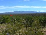
| + | Image:2009-01-25_32_-111.jpg|Casa Grande, Arizona | ||
</gallery> | </gallery> | ||
[[Category:Expeditions]] | [[Category:Expeditions]] | ||
[[Category:Expeditions with photos]] | [[Category:Expeditions with photos]] | ||
Revision as of 06:29, 4 February 2009
| Sun 25 Jan 2009 in Casa Grande: 32.0374503, -111.4350494 geohashing.info google osm bing/os kml crox |
Expeditions
Location was about 1/4 mile within the Tohono O'odham Indian Reservation which does not allow off road tresspassing. While we were estimating the location from a pullout on the highway, agents of the US Border Patrol stopped to "make sure we weren't doing something that would get us in trouble". Taking pictures was the quick answer since we didn't want to try to explain geohashing (probably at the local substation). We opted for a 2 mile hike at a nearby trailhead.
Casa Grande, Arizona
