Difference between revisions of "2009-03-08 40 -104"
imported>Sethant (→Achievements: No Tresspassing!) |
|||
| (23 intermediate revisions by 13 users not shown) | |||
| Line 1: | Line 1: | ||
__NOTOC__ | __NOTOC__ | ||
{{meetup graticule | {{meetup graticule | ||
| − | | map=<map lat="40" lon="-104" date="2009-03- | + | | map=<map lat="40" lon="-104" date="2009-03-08" /> |
| lat=40 | | lat=40 | ||
| lon=-104 | | lon=-104 | ||
| − | | date=2009-03- | + | | date=2009-03-08 |
}} | }} | ||
| − | The | + | The [[Greeley, Colorado|Greeley]] geohash for 8 March 2008 was located in a suburban area northeast of Fort Collins off of E Mulberry St. (Colorado State Highway 14). |
I arrived just before 4 p.m. and, as expected, found that the area lay on private property, near the intersection of Boulder Avenue and Boulder Circle. :) Given that there didn't appear to be anybody home, and several unfriendly dogs resided within the fenced-in area, I took a few photos near the property line, and proceeded on to bike through Timnath and south Fort Collins. | I arrived just before 4 p.m. and, as expected, found that the area lay on private property, near the intersection of Boulder Avenue and Boulder Circle. :) Given that there didn't appear to be anybody home, and several unfriendly dogs resided within the fenced-in area, I took a few photos near the property line, and proceeded on to bike through Timnath and south Fort Collins. | ||
| + | |||
| + | It was only later that I realized that my geohash documentation had the wrong date on it. Alas. | ||
==Participants== | ==Participants== | ||
| Line 24: | Line 26: | ||
<gallery widths="160px" align=center> | <gallery widths="160px" align=center> | ||
| − | Image:2009-03- | + | Image:2009-03-08_40_-104_Pic_1.JPG|Me, at the geohash site, in my glamorous bike helmet. I believe the hash site lies behind the fence visible over my left shoulder. |
</gallery> | </gallery> | ||
[[Category:Expeditions]] | [[Category:Expeditions]] | ||
[[Category:Expeditions with photos]] | [[Category:Expeditions with photos]] | ||
| + | [[Category:Coordinates not reached]] | ||
| + | [[Category:Not reached - No public access]] | ||
| + | {{location|US|CO|LR}} | ||
Latest revision as of 14:25, 29 January 2021
| Sun 8 Mar 2009 in 40,-104: 40.5792666, -104.9768719 geohashing.info google osm bing/os kml crox |
The Greeley geohash for 8 March 2008 was located in a suburban area northeast of Fort Collins off of E Mulberry St. (Colorado State Highway 14).
I arrived just before 4 p.m. and, as expected, found that the area lay on private property, near the intersection of Boulder Avenue and Boulder Circle. :) Given that there didn't appear to be anybody home, and several unfriendly dogs resided within the fenced-in area, I took a few photos near the property line, and proceeded on to bike through Timnath and south Fort Collins.
It was only later that I realized that my geohash documentation had the wrong date on it. Alas.
Participants
Just myself. -- Sethant
Achievements


Pictures
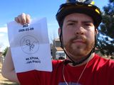
Me, at the geohash site, in my glamorous bike helmet. I believe the hash site lies behind the fence visible over my left shoulder.
