Difference between revisions of "2009-03-29 44 -92"
From Geohashing
imported>Josemite (New page: {{meetup graticule | map=<map lat="44" lon="-92" date="2009-03-29" /> | lat=44 | lon=-92 | date=2009-03-29 }} Went to our second geohash, this one again fairly close and again outside our...) |
imported>Josemite |
||
| Line 8: | Line 8: | ||
Went to our second geohash, this one again fairly close and again outside our home graticule. This time we ended up parking behind someone's house before bushwacking over to the hash (no trespassing sign or yelling owner at our parking spot luckily). After making our way through the thick woods, we came across the tree farm, to discover it had a very tall fence around the whole area. While there were no posted signs, the message was pretty clear. A couple hundred feet from the hash, we were forced to take some pictures then turn back. | Went to our second geohash, this one again fairly close and again outside our home graticule. This time we ended up parking behind someone's house before bushwacking over to the hash (no trespassing sign or yelling owner at our parking spot luckily). After making our way through the thick woods, we came across the tree farm, to discover it had a very tall fence around the whole area. While there were no posted signs, the message was pretty clear. A couple hundred feet from the hash, we were forced to take some pictures then turn back. | ||
| + | {{No trespassing geohash | ||
| + | | latitude = 44 | ||
| + | | longitude = -92 | ||
| + | | date = 2009-03-29 | ||
| + | | name = All Attendees | ||
| + | | image = 2009-03-29_44_-92_Josemite_and_Axeman_2.JPG | ||
| + | }} | ||
<gallery caption="Josemite, Axeman and Tesserra visit a tree farm" widths="200px" heights="200px" perrow="3"> | <gallery caption="Josemite, Axeman and Tesserra visit a tree farm" widths="200px" heights="200px" perrow="3"> | ||
| Line 14: | Line 21: | ||
Image:2009-03-29_44_-92_Josemite_and_Tesserra.JPG|Josemite and his girlfriend Tesserra | Image:2009-03-29_44_-92_Josemite_and_Tesserra.JPG|Josemite and his girlfriend Tesserra | ||
</gallery> | </gallery> | ||
| + | |||
[[Category:Expeditions]] | [[Category:Expeditions]] | ||
| − | [[Category:Coordinates reached]] | + | [[Category:Expeditions with photos]] |
| + | [[Category:Coordinates not reached]] | ||
| + | [[Category:Failed - No public access]] | ||
Revision as of 23:25, 29 March 2009
| Sun 29 Mar 2009 in 44,-92: 44.6765237, -92.8240546 geohashing.info google osm bing/os kml crox |
Went to our second geohash, this one again fairly close and again outside our home graticule. This time we ended up parking behind someone's house before bushwacking over to the hash (no trespassing sign or yelling owner at our parking spot luckily). After making our way through the thick woods, we came across the tree farm, to discover it had a very tall fence around the whole area. While there were no posted signs, the message was pretty clear. A couple hundred feet from the hash, we were forced to take some pictures then turn back.
All Attendees earned the No trespassing consolation prize
|
- Josemite, Axeman and Tesserra visit a tree farm
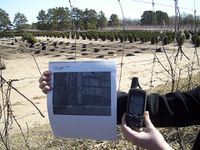
The google satellite image and our GPS. The GPS says we're about 250ft from the hash.
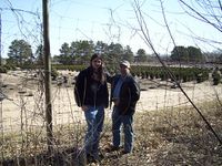
Josemite and Axeman posing in front of the fence in our way
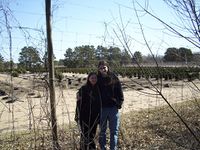
Josemite and his girlfriend Tesserra


