Difference between revisions of "2009-04-19 51 -1"
imported>Forawhile (Creating and filling in page.) |
imported>Forawhile m (We don't need that header.) |
||
| Line 6: | Line 6: | ||
| graticule_link=Swindon, United Kingdom}} | | graticule_link=Swindon, United Kingdom}} | ||
| − | + | With only my non-3G, non-A–GPS-enabled iPhone to help me get there, I set out on my bicycle. Quite an enjoyable ride, relatively mild weather, about 10℃ with only a little headwind on the return trip. Unfortunately as I came close to the Geohash, the road leading out of the village of Wootton became a national speed limit road without street lights and the Geohash was located in the field to my left, which I couldn’t find an easy way into or accurately be able to find the Geohash in. | |
| − | + | —[[User:Forawhile|Forawhile]] 04:38, 20 April 2009 (UTC) | |
| − | No photographs because I went out at night and the | + | No photographs because I went out at night and the iPhone’s camera can’t deal. Screenshots from the Maps app instead: |
<gallery> | <gallery> | ||
Image:2009_04_19_51_-1_1.jpg|The generated location, shown by the red pin, with GPS coordinates. The purple pin shows my estimated location. | Image:2009_04_19_51_-1_1.jpg|The generated location, shown by the red pin, with GPS coordinates. The purple pin shows my estimated location. | ||
| − | Image:2009_04_19_51_-1_2.jpg|The | + | Image:2009_04_19_51_-1_2.jpg|The iPhone’s estimate for my location (the large circle on the map, centred with a blue dot: not very accurate), the purple pin shows my own estimate. The red pin shows the generated location. |
| − | Image:2009_04_19_51_-1_3.jpg|The rough distance with directions. I | + | Image:2009_04_19_51_-1_3.jpg|The rough distance with directions. I didn’t take this route; I went via the city centre and Botley instead. |
</gallery> | </gallery> | ||
Revision as of 04:38, 20 April 2009
| Sun 19 Apr 2009 in Swindon, United Kingdom: 51.7094242, -1.3281098 geohashing.info google osm bing/os kml crox |
With only my non-3G, non-A–GPS-enabled iPhone to help me get there, I set out on my bicycle. Quite an enjoyable ride, relatively mild weather, about 10℃ with only a little headwind on the return trip. Unfortunately as I came close to the Geohash, the road leading out of the village of Wootton became a national speed limit road without street lights and the Geohash was located in the field to my left, which I couldn’t find an easy way into or accurately be able to find the Geohash in.
—Forawhile 04:38, 20 April 2009 (UTC)
No photographs because I went out at night and the iPhone’s camera can’t deal. Screenshots from the Maps app instead:
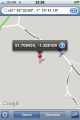
The generated location, shown by the red pin, with GPS coordinates. The purple pin shows my estimated location.
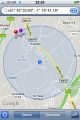
The iPhone’s estimate for my location (the large circle on the map, centred with a blue dot: not very accurate), the purple pin shows my own estimate. The red pin shows the generated location.
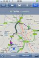
The rough distance with directions. I didn’t take this route; I went via the city centre and Botley instead.


