Difference between revisions of "2009-06-02 40 -74"
imported>Jevanyn m (→Participants) |
imported>FippeBot m (Location) |
||
| (6 intermediate revisions by one other user not shown) | |||
| Line 1: | Line 1: | ||
<!-- If you did not specify these parameters in the template, please substitute appropriate things for IMAGE, LAT, LON, and DATE (YYYY-MM-DD format) --> | <!-- If you did not specify these parameters in the template, please substitute appropriate things for IMAGE, LAT, LON, and DATE (YYYY-MM-DD format) --> | ||
| − | + | ||
{{meetup graticule | {{meetup graticule | ||
| − | | lat= | + | | lat=40 |
| − | | lon= | + | | lon=-74 |
| − | | date= | + | | date=2009-06-02 |
}} | }} | ||
| Line 13: | Line 13: | ||
== Plans == | == Plans == | ||
| − | + | [[User:Jevanyn|Jevanyn]]: The geohash is only a couple of miles from my house, so I'm going to try to bike there, if the weather cooperates. Atlernately, I need to pick up some lumber from Home Depot anyway, which will take me to Bridgewater Commons this evening. Chimney Rock Road won't be very far out of my way, and eight-foot 2x4's will make for an impressive if temporary XKCD marker :-). | |
== Expedition == | == Expedition == | ||
| + | The weather did cooperate, but I had other errands to run as well, so I drove up Chimney Rock Rd., past the quarry, into Bernardsville. When I got there, I realized that there was no empty lot along the road; it was one house after another. Thwarted by private property once again, and knowing that the police station was a block and a half away, I took some photos and left quietly. | ||
| − | + | ''On further review, I think I was a block away from the geohash. I either misread the satellite photo or forgot to bring it with me when I went.'' | |
| − | |||
| − | |||
== Photos == | == Photos == | ||
| − | <gallery | + | <gallery> |
| − | Image:2009- | + | Image:2009-06-02 40 -74 100 8238.JPG | Businesses across the street (sign is illegible on Google Street View) |
| − | Image:2009- | + | Image:2009-06-02 40 -74 100 8239.JPG | Hmmm, very popular name for streets lately :-/ |
| + | Image:2009-06-02 40 -74 100 8240.JPG | It's a rust monster! | ||
| + | Image:2009-06-02 40 -74 100 8241.JPG | View of the geohash from across the street | ||
</gallery> | </gallery> | ||
| − | |||
| − | |||
| − | |||
| − | |||
| − | + | ||
| − | |||
| − | |||
[[Category:Expeditions]] | [[Category:Expeditions]] | ||
[[Category:Expeditions with photos]] | [[Category:Expeditions with photos]] | ||
| − | |||
[[Category:Expedition without GPS]] | [[Category:Expedition without GPS]] | ||
| − | |||
| − | |||
| − | |||
| − | |||
| − | |||
| − | |||
| − | |||
[[Category:Coordinates not reached]] | [[Category:Coordinates not reached]] | ||
| − | |||
| − | |||
[[Category:Not reached - No public access]] | [[Category:Not reached - No public access]] | ||
| − | + | {{location|US|NJ|SO}} | |
| − | |||
| − | |||
Latest revision as of 03:42, 8 August 2019
| Tue 2 Jun 2009 in 40,-74: 40.5979368, -74.5609896 geohashing.info google osm bing/os kml crox |
Participants
Plans
Jevanyn: The geohash is only a couple of miles from my house, so I'm going to try to bike there, if the weather cooperates. Atlernately, I need to pick up some lumber from Home Depot anyway, which will take me to Bridgewater Commons this evening. Chimney Rock Road won't be very far out of my way, and eight-foot 2x4's will make for an impressive if temporary XKCD marker :-).
Expedition
The weather did cooperate, but I had other errands to run as well, so I drove up Chimney Rock Rd., past the quarry, into Bernardsville. When I got there, I realized that there was no empty lot along the road; it was one house after another. Thwarted by private property once again, and knowing that the police station was a block and a half away, I took some photos and left quietly.
On further review, I think I was a block away from the geohash. I either misread the satellite photo or forgot to bring it with me when I went.
Photos
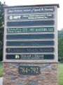
Businesses across the street (sign is illegible on Google Street View)
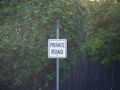
Hmmm, very popular name for streets lately :-/

It's a rust monster!
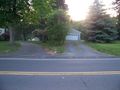
View of the geohash from across the street


