Difference between revisions of "2009-06-22 48 -123"
imported>Wenslayer m |
imported>Wenslayer m (Cole->Coles) |
||
| Line 9: | Line 9: | ||
}}__NOTOC__ | }}__NOTOC__ | ||
== Location == | == Location == | ||
| − | On the beach or just off shore in | + | On the beach or just off shore in Coles Bay, off the Saanich peninsula. Closest major roads are West Saanich and McTavish. Looks like it could be on private property on an Indian reservation. |
== Participants == | == Participants == | ||
| Line 39: | Line 39: | ||
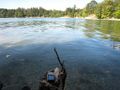
Image:2009-06-22 48 -123.IMG 3772.jpg| View from the boat launch towards the Geohash point. | Image:2009-06-22 48 -123.IMG 3772.jpg| View from the boat launch towards the Geohash point. | ||
Image:2009-06-22 48 -123.IMG 3771.jpg| Getting closer to the Geohash point. | Image:2009-06-22 48 -123.IMG 3771.jpg| Getting closer to the Geohash point. | ||
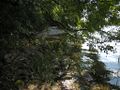
| − | Image:2009-06-22 48 -123.IMG 3760.jpg| Sure is a beautiful view of | + | Image:2009-06-22 48 -123.IMG 3760.jpg| Sure is a beautiful view of Coles Bay from here! |
Image:2009-06-22 48 -123.IMG 3770.jpg| Almost there, just have to get around these bushes ahead. | Image:2009-06-22 48 -123.IMG 3770.jpg| Almost there, just have to get around these bushes ahead. | ||
Image:2009-06-22 48 -123.IMG 3769.jpg| The incredibly dense bush ahead. | Image:2009-06-22 48 -123.IMG 3769.jpg| The incredibly dense bush ahead. | ||
Revision as of 05:50, 3 August 2010
| Mon 22 Jun 2009 in 48,-123: 48.6261184, -123.4662374 geohashing.info google osm bing/os kml crox |
Location
On the beach or just off shore in Coles Bay, off the Saanich peninsula. Closest major roads are West Saanich and McTavish. Looks like it could be on private property on an Indian reservation.
Participants
- Wenslayer: will bike the loooong way home after work
Plans
What the heck, I'll just bike out there first, see if I can reach it and then head home. I got my new GPS unit, a Garmin eTrex Summit HC, along with a handle bar mount, so I should be able to use the electronic compass to home it on it.
Expedition
I left work shortly after 5pm by bike, packing my GPS, point and shoot, and a drink. I got on the Pat Bay Hwy, and simply headed north. Once I hit McTavish (the exit for the airport), I turned left. I rode it all the way until I hit West Saanich Rd, took a left and then a right on Pauquachin Lane. It descended toward the water, and where I thought would be houses were just cleared lots. It sort of ended in the bush, but there was a small trail that continued. I saw no sign of private property, so I pressed on.
I walked my bike upright on its back tire through the bushes, but when it started getting steep near the water, I set it aside and continued sans ride. I made it down to the beach with less than 100m to go, pointing me along the shore. I kept walking along the beach, cringing each time a rock grated against my bike shoe clip part underneath. I had do a little bush-wacking to get to the closest point.
I reached the closest point on the beach, a mere 8m to go! Alas, if I'd had more time, I would have surely stripped and waded out to the spot, but without a towel, and a place to be within the hour, I felt the pressure to simply record this point and head back.
I took a few pictures, including myself this time, and made my way back, snapping a few pics looking toward the spot. It's a good thing I left when I did, for I encountered a fierce head-wind on the way home, but made it just in time.
Total ride distance: 41km.
Tracklog
Coming soon, perhaps.
Photos
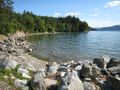
View from the boat launch towards the Geohash point.
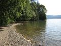
Getting closer to the Geohash point.
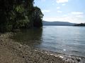
Sure is a beautiful view of Coles Bay from here!
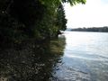
Almost there, just have to get around these bushes ahead.
The incredibly dense bush ahead.
The GPS unit on a log, pointing to its desired destination out in the water.
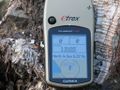
GPS showing I was a mere 8m away from the hash point. Argh!
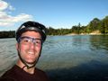
'Tis me!


