Difference between revisions of "2009-06-28 50 -1"
From Geohashing
imported>Sermoa m (Still getting used to Mediawiki!) |
imported>Sermoa m (Actually it turned out to be a little further from Botley train station.) |
||
| Line 22: | Line 22: | ||
[http://maps.google.co.uk/maps?f=d&source=s_d&saddr=hedge+end+railway+station&daddr=50.910206%C2%B0,+-1.306221&geocode=FaInCQMdzj3s_yGKIOlx9F7Tqg%3BFf7TCAMdkxHs_w&hl=en&mra=ls&dirflg=w&sll=50.92107,-1.30046&sspn=0.027053,0.079737&ie=UTF8&t=h&z=14 1.9 mile walk from Hedge End train station] | [http://maps.google.co.uk/maps?f=d&source=s_d&saddr=hedge+end+railway+station&daddr=50.910206%C2%B0,+-1.306221&geocode=FaInCQMdzj3s_yGKIOlx9F7Tqg%3BFf7TCAMdkxHs_w&hl=en&mra=ls&dirflg=w&sll=50.92107,-1.30046&sspn=0.027053,0.079737&ie=UTF8&t=h&z=14 1.9 mile walk from Hedge End train station] | ||
| − | [http://maps.google.co.uk/maps?f=d&source=s_d&saddr= | + | [http://maps.google.co.uk/maps?f=d&source=s_d&saddr=50.916428,-1.258578&daddr=50.910206%C2%B0,+-1.306221&geocode=%3BFf7TCAMdkxHs_w&hl=en&mra=dme&mrcr=0&mrsp=0&sz=15&dirflg=w&sll=50.913397,-1.275787&sspn=0.013529,0.039868&ie=UTF8&ll=50.912964,-1.281581&spn=0.027058,0.079737&t=h&z=14 2.4 mile walk from Botley train station] |
Not far from the M27. | Not far from the M27. | ||
[[Category:Expedition planning]] | [[Category:Expedition planning]] | ||
Revision as of 10:56, 27 June 2009
| Sun 28 Jun 2009 in Southampton: 50.9102060, -1.3062207 geohashing.info google osm bing/os kml crox |
Location
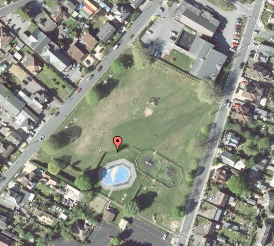
Right in the middle of Hedge End recreation ground! Plenty of space to play, pubs and cafes and shops nearby. A perfect geohash!
Participants
Details
1.9 mile walk from Hedge End train station
2.4 mile walk from Botley train station
Not far from the M27.
