Difference between revisions of "2009-07-04 40 -74"
(→Photos) |
imported>Benjw (re-catting & removing unused bits of expedition template) |
||
| Line 1: | Line 1: | ||
| − | |||
| − | |||
| − | |||
| − | |||
{{meetup graticule | {{meetup graticule | ||
| lat=40 | | lat=40 | ||
| Line 9: | Line 5: | ||
}} | }} | ||
| − | |||
__NOTOC__ | __NOTOC__ | ||
== Location == | == Location == | ||
| Line 32: | Line 27: | ||
== Photos == | == Photos == | ||
Will be posted as soon as [[User:Knitting Duck|Knitting Duck]] collects them from various cameras and has a chance to get them uploaded. Expect some lovely shots of flora and fauna that have little (or, y'know, nothing) to do with the hash, but are still quite nice to look at. | Will be posted as soon as [[User:Knitting Duck|Knitting Duck]] collects them from various cameras and has a chance to get them uploaded. Expect some lovely shots of flora and fauna that have little (or, y'know, nothing) to do with the hash, but are still quite nice to look at. | ||
| − | |||
| − | |||
| − | |||
| − | |||
| − | |||
| − | |||
| − | |||
| − | |||
| − | |||
| − | |||
[[Category:Expeditions]] | [[Category:Expeditions]] | ||
| − | |||
| − | |||
| − | |||
| − | |||
| − | |||
| − | |||
| − | |||
| − | |||
| − | |||
| − | |||
| − | |||
| − | |||
[[Category:Coordinates not reached]] | [[Category:Coordinates not reached]] | ||
| − | |||
| − | |||
[[Category:Not reached - No public access]] | [[Category:Not reached - No public access]] | ||
| − | |||
| − | |||
| − | |||
Revision as of 16:52, 8 August 2010
| Sat 4 Jul 2009 in 40,-74: 40.2025619, -74.8738082 geohashing.info google osm bing/os kml crox |
Location
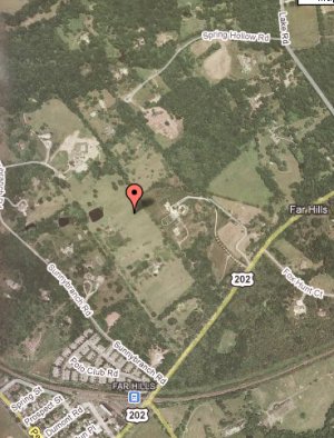
A field somewhere in Far Hills, NJ. At least it doesn't look like a raptor-infested swamp this time!

Participants
- Knitting Duck and three friends
Plans
- Knitting Duck is in the pre-planning stage: interrogating Google about the location, contacting and convincing possible compatriots, and preparing a stash of geohash necessities. We hope to attempt the hash around 4pm-ish (plus or minus about half an hour) local time, thus allowing for a margin of stupidity. Perhaps we will bring sandwiches and make this a picnic geohash.
Expedition
Well, that wasn't completely a bust!
The coordinates turned out to be unreachable through various forms of the NJ state flower. We encountered one No Trespassing sign, two gated driveways, one person who appeared to live in what can only be termed a castle on a hill who told us to please go away and bother somebody else, and one fence. In the end, we decided we'd done our best but it just was not to be.
So instead we headed about three miles north to a park we'd seen along the road in Bernardsville. There we discovered a bridge, a stream, fish being hunted by an unsuccessful water snake, picnic tables, a lake, a buttload of geese, 9 ducks, a small waterfall, and a delightful picnic lunch. Well, actually we brought that last along with us.
A wonderful time was had by all. :-)
Photos
Will be posted as soon as Knitting Duck collects them from various cameras and has a chance to get them uploaded. Expect some lovely shots of flora and fauna that have little (or, y'know, nothing) to do with the hash, but are still quite nice to look at.