Difference between revisions of "2009-07-11 40 -74"
imported>Zubenelgenubi |
imported>FippeBot m (Location) |
||
| Line 34: | Line 34: | ||
[[Category:Coordinates not reached]] | [[Category:Coordinates not reached]] | ||
[[Category:Not reached - No public access]] | [[Category:Not reached - No public access]] | ||
| + | {{location|US|NJ|MN}} | ||
Latest revision as of 04:26, 8 August 2019
| Sat 11 Jul 2009 in 40,-74: 40.3206566, -74.1604565 geohashing.info google osm bing/os kml crox |
Participants
Plans
The hash coordinates were near a road in Colts Neck, Monmouth County, in the craw between the branches of the Swimming River Reservoir. A nearby large oval racetrack visible on the aerial photos made it clear that horses were likely to be around.
Expedition
Propelled by a strong west wind, I was early for once and killed some time in nearby Thompson Park. The geohash fell in a corral which was empty, although a few horses were grazing in the neighboring corral.
While the geohash was only 25 feet away, I reined in the impulse to climb over the fence, since things could get unstable and it did not mare-it tresspassing...that's enough.
Photos
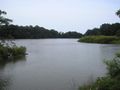
Swimming River Reservoir
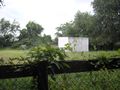
The Geohash Corral
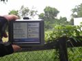
Close to the coordinates

The horses behind me don't seem to realize how close they are to getting a Stable Potato Geohash Achievement or something
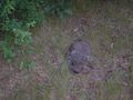
Poor guy just missed reaching the geohash


