Difference between revisions of "2009-07-12 42 -72"
imported>Sara m (saving to expand subst:Expedition) |
imported>Sara (Creating the page) |
||
| Line 1: | Line 1: | ||
| − | |||
<!-- If you did not specify these parameters in the template, please substitute appropriate things for IMAGE, LAT, LON, and DATE (YYYY-MM-DD format) --> | <!-- If you did not specify these parameters in the template, please substitute appropriate things for IMAGE, LAT, LON, and DATE (YYYY-MM-DD format) --> | ||
| − | + | [[Image:{{{image|2009_07_12_42_-72_grin.jpg}}}|thumb|left]] | |
| − | [[Image:{{{image| | ||
| − | |||
{{meetup graticule | {{meetup graticule | ||
| − | | lat= | + | | lat=42 |
| − | | lon= | + | | lon=-72 |
| date=2009-07-12 | | date=2009-07-12 | ||
}} | }} | ||
| Line 14: | Line 11: | ||
== Location == | == Location == | ||
| + | The side of a suburban street in West Springfield, Massachusetts. We went to the wrong street, because I misread the map. | ||
== Participants == | == Participants == | ||
| + | [[User:Sara|Sara]] with her daughter and son. | ||
| − | |||
| + | == Expedition == | ||
| − | + | It was a disorganized day, so the kids and I didn't have much time for the expedition, but I wanted to go anyway because we haven't geohashed in a few days. I looked at Google maps and decided that although we just purchased a GPS, we didn't need it today, because the site is so clearly right at the edge of the pavement, across the street from the midpoint between the second and third house after the corner. We left the GPS at home. | |
| + | We drove over there and parked the car near what I thought was the correct point, and I wondered why Google satellite view hadn't shown that extra house and extra street, since neither the house nor the street looked particularly new. Anyway, we were right at the edge of the pavement, across the street from the midpoint between the second and third house after the corner, so we took pictures and wrote "XKCD" on the pavement. Then, because we were in a hurry, we got in the car and left. We would have liked to visit the nearby state park and/or the nearby municipal park, but we didn't have time. | ||
| − | + | Then we went home, making a couple wrong turns along the way, which is in keeping with the day's theme, because when I looked again at Google satellite view just now, I realized that we were near the wrong corner; we were one block east of the hashpoint. Oh well. | |
| + | I'm calling this "Not reached - Technology" but I don't know if that's the correct category. | ||
== Photos == | == Photos == | ||
<gallery perrow="3"> | <gallery perrow="3"> | ||
| − | Image: | + | Image:2009_07_12_42_-72_grin.jpg | The grin, at the wrong place. Son is busy looking at a booklet of pictures of toy cars. |
| − | Image: | + | Image:2009_07_12_42_-72_go_sox.jpg | My daughter took this picture from the back seat of the car on the way home. Go Sox! |
| + | Image:2009_07_12_42_-72_river.jpg | The Connecticut River, which separates West Springfield from Springfield. My daughter took this picture from the car too. | ||
</gallery> | </gallery> | ||
| − | |||
| − | |||
| − | |||
| − | |||
| − | |||
| − | |||
| − | |||
[[Category:Expeditions]] | [[Category:Expeditions]] | ||
| + | [[Category:Expedition without GPS]] | ||
[[Category:Expeditions with photos]] | [[Category:Expeditions with photos]] | ||
| − | |||
| − | |||
| − | |||
| − | |||
| − | |||
| − | |||
| − | |||
| − | |||
| − | |||
[[Category:Coordinates not reached]] | [[Category:Coordinates not reached]] | ||
| − | |||
| − | |||
| − | |||
[[Category:Not reached - Technology]] | [[Category:Not reached - Technology]] | ||
| − | |||
| − | |||
Revision as of 00:44, 13 July 2009

| Sun 12 Jul 2009 in 42,-72: 42.1025873, -72.6765493 geohashing.info google osm bing/os kml crox |
Location
The side of a suburban street in West Springfield, Massachusetts. We went to the wrong street, because I misread the map.
Participants
Sara with her daughter and son.
Expedition
It was a disorganized day, so the kids and I didn't have much time for the expedition, but I wanted to go anyway because we haven't geohashed in a few days. I looked at Google maps and decided that although we just purchased a GPS, we didn't need it today, because the site is so clearly right at the edge of the pavement, across the street from the midpoint between the second and third house after the corner. We left the GPS at home.
We drove over there and parked the car near what I thought was the correct point, and I wondered why Google satellite view hadn't shown that extra house and extra street, since neither the house nor the street looked particularly new. Anyway, we were right at the edge of the pavement, across the street from the midpoint between the second and third house after the corner, so we took pictures and wrote "XKCD" on the pavement. Then, because we were in a hurry, we got in the car and left. We would have liked to visit the nearby state park and/or the nearby municipal park, but we didn't have time.
Then we went home, making a couple wrong turns along the way, which is in keeping with the day's theme, because when I looked again at Google satellite view just now, I realized that we were near the wrong corner; we were one block east of the hashpoint. Oh well.
I'm calling this "Not reached - Technology" but I don't know if that's the correct category.
Photos
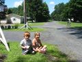
The grin, at the wrong place. Son is busy looking at a booklet of pictures of toy cars.
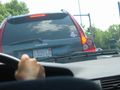
My daughter took this picture from the back seat of the car on the way home. Go Sox!
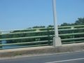
The Connecticut River, which separates West Springfield from Springfield. My daughter took this picture from the car too.

