Difference between revisions of "2009-07-18 53 -1"
imported>Scruffy Bumblebee m |
imported>FippeBot m (Location) |
||
| (3 intermediate revisions by 3 users not shown) | |||
| Line 12: | Line 12: | ||
== Participants == | == Participants == | ||
| − | [[User:Scruffy Bumblebee|Scruffy Bumblebee]] | + | *[[User:Scruffy Bumblebee|Scruffy Bumblebee]] |
| − | Non-geohasher dragged along for the ride | + | *Non-geohasher dragged along for the ride |
== The Plan == | == The Plan == | ||
| − | With the hashpoint just a few minutes off my normal cycle into Uni,how the hell could I resist? | + | With the hashpoint just a few minutes off my normal cycle into Uni, how the hell could I resist? |
Afternoon cycle in the sunshine, within a few miles of my house. A good look at some maps made me confident I could find the hashpoint even without a GPS. Well... | Afternoon cycle in the sunshine, within a few miles of my house. A good look at some maps made me confident I could find the hashpoint even without a GPS. Well... | ||
| + | |||
== Expedition == | == Expedition == | ||
| − | After an easy ( | + | After an easy (lazy) start to the expedition, it soon became clear that my new (but recycled) bike Suzie was inclined to give up regularly on the concept of brakes. Oh well, so she was going to be as much of a character as a bike can be. Still, we arrived at the field where the hashpoint lay. There didn't seem to be an opening in the hedge, so after pacing out the exact line we needed to follow from the houses opposite to the hashpoint (thanks streetview) it was time to navigate the large thorny hedge directly in our path, and the bed of long nettles acting like a prickly moat before the thorny wall. Many scratches later (it was a particularly thick thorny hedge), with nettlestung legs and the raptor-like result of a thorny branch having been twanged in my face (slapstick style), we were greeted by a wholly unexpected sight. Seems the new university campus was to be placed in this field, around a large and very very wet lake, which had been dug within the last week and was now covering most of the field, including the hashpoint. Failure! |
| Line 53: | Line 54: | ||
| − | + | ||
[[Category:Expeditions]] | [[Category:Expeditions]] | ||
[[Category:Expeditions with photos]] | [[Category:Expeditions with photos]] | ||
| Line 62: | Line 63: | ||
[[Category:Coordinates not reached]] | [[Category:Coordinates not reached]] | ||
[[Category:Not reached - Technology]] | [[Category:Not reached - Technology]] | ||
| + | {{location|GB|ENG|YOR}} | ||
Latest revision as of 04:37, 8 August 2019
| Sat 18 Jul 2009 in 53,-1: 53.9482294, -1.0370804 geohashing.info google osm bing/os kml crox |
Location
In a nice big field on the outskirts of York, just up from the University.
Participants
- Non-geohasher dragged along for the ride
The Plan
With the hashpoint just a few minutes off my normal cycle into Uni, how the hell could I resist?
Afternoon cycle in the sunshine, within a few miles of my house. A good look at some maps made me confident I could find the hashpoint even without a GPS. Well...
Expedition
After an easy (lazy) start to the expedition, it soon became clear that my new (but recycled) bike Suzie was inclined to give up regularly on the concept of brakes. Oh well, so she was going to be as much of a character as a bike can be. Still, we arrived at the field where the hashpoint lay. There didn't seem to be an opening in the hedge, so after pacing out the exact line we needed to follow from the houses opposite to the hashpoint (thanks streetview) it was time to navigate the large thorny hedge directly in our path, and the bed of long nettles acting like a prickly moat before the thorny wall. Many scratches later (it was a particularly thick thorny hedge), with nettlestung legs and the raptor-like result of a thorny branch having been twanged in my face (slapstick style), we were greeted by a wholly unexpected sight. Seems the new university campus was to be placed in this field, around a large and very very wet lake, which had been dug within the last week and was now covering most of the field, including the hashpoint. Failure!
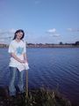
After working out by line of sight the approximate location of the hashpoint, it seems we were only a few meters off. Unwilling to get stuck in the newly dug sinky mud around the lake, we estimated the nearest point, and left it there.
On the return leg, as if to rub in the failure, we were attacked by wild ponies who left nasty cuts down my arms. Or, alternatively, I was repeatedly nipped by a foal I stroked. But it was cute enough to make the cuts totally worthwhile.
Photos
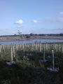
Where the field used to be.
More ex-field.
The least soggy almost-hash around.
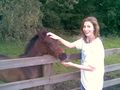
Man eating foal.


Consolation Prize
Scruffy Bumblebee earned the My kingdom for a boat consolation prize
|