Difference between revisions of "2009-08-02 40 -89"
imported>Dvdllr (→Expedition) |
imported>FippeBot m (Location) |
||
| (12 intermediate revisions by one other user not shown) | |||
| Line 1: | Line 1: | ||
| + | __NOTOC__ | ||
{{meetup graticule | {{meetup graticule | ||
| lat=40 | | lat=40 | ||
| Line 4: | Line 5: | ||
| date=2009-08-02 | | date=2009-08-02 | ||
}} | }} | ||
| − | |||
== Location == | == Location == | ||
The location was in a field just off of N West Street, on the north side of Danvers, Illinois. | The location was in a field just off of N West Street, on the north side of Danvers, Illinois. | ||
== Participants == | == Participants == | ||
| − | * [[User:dvdllr|Dvdllr]] | + | * [[User:dvdllr|Dvdllr]] & Rachel |
== Plans == | == Plans == | ||
| Line 15: | Line 15: | ||
== Expedition == | == Expedition == | ||
| − | I left the apartment around 1:45 with wife in tow, who was going to act as my navigator and photographer while I was driving. Because I don't have a GPS, I asked her to take lots of pictures along the way, because I needed my route recorded in order to win the Tron achievement, should I make it to the hashpoint. The point was about half an hour away, just north of the little town of Danvers, Illinois. We passed through town on the way to the spot, which was about a stone's throw from the north edge of town. The hashpoint was very close to the road (in fact, if you put the coordinates into Google Maps, it directs you to the street address), but alas, it was not on the road proper. Because satellite views of the area are pretty grainy, I relied on Bing | + | I left the apartment around 1:45 PM with wife in tow, who was going to act as my navigator and photographer while I was driving. Because I don't have a GPS, I asked her to take lots of pictures along the way, because I needed my route recorded in order to win the Tron achievement, should I make it to the hashpoint. The point was about half an hour away, just north of the little town of Danvers, Illinois. We passed through town on the way to the spot, which was about a stone's throw from the north edge of town. The hashpoint was very close to the road (in fact, if you put the coordinates into Google Maps, it directs you to the street address), but alas, it was not on the road proper. Because satellite views of the area are pretty grainy, I relied on Bing bird's eye views (helicopter, I guess) to show me where it was. The hashpoint was about 10 crop rows into the field. I could tell we were in the right place because of the triangle shaped indentation in the field just west of the hashpoint. It is August, after all, and the corn is tall and thick. There wouldn't be any possible way to get in there without damaging the crops; and besides, it's private property and it wasn't apparent where the owner of the crops lived. We took a picture of the hashpoint from the side of the road (or where it would be if you could see through the corn), and headed out back towards home. |
== Photos == | == Photos == | ||
| − | <gallery perrow=" | + | <gallery perrow="5"> |
Image:2009-08-02 40 -89 1.jpg | Ambassador forms in hand, and excited to go! | Image:2009-08-02 40 -89 1.jpg | Ambassador forms in hand, and excited to go! | ||
Image:2009-08-02 40 -89 2.jpg | Recording the event for posterity (I think I was singing along to ZZ Top) | Image:2009-08-02 40 -89 2.jpg | Recording the event for posterity (I think I was singing along to ZZ Top) | ||
| Line 31: | Line 31: | ||
==Achievements== | ==Achievements== | ||
| + | {{#vardefine:ribbonwidth|800px}} | ||
{{No trespassing | {{No trespassing | ||
| Line 36: | Line 37: | ||
| longitude = -89 | | longitude = -89 | ||
| date = 2009-08-02 | | date = 2009-08-02 | ||
| − | | name = Dvdllr | + | | name = [[User:Dvdllr|Dvdllr]] |
}} | }} | ||
| Line 45: | Line 46: | ||
[[Category:Coordinates not reached]] | [[Category:Coordinates not reached]] | ||
[[Category:Not reached - No public access]] | [[Category:Not reached - No public access]] | ||
| + | {{location|US|IL|ML}} | ||
Latest revision as of 04:57, 8 August 2019
| Sun 2 Aug 2009 in 40,-89: 40.5333294, -89.1774206 geohashing.info google osm bing/os kml crox |
Location
The location was in a field just off of N West Street, on the north side of Danvers, Illinois.
Participants
- Dvdllr & Rachel
Plans
Prepared by printing off various aerial views of the hashpoint - and since the hashpoint was in a field, also brought along several Ambassador forms, just in case. Also prepared the route I would take, which wouldn't cross over itself.
Expedition
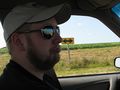
I left the apartment around 1:45 PM with wife in tow, who was going to act as my navigator and photographer while I was driving. Because I don't have a GPS, I asked her to take lots of pictures along the way, because I needed my route recorded in order to win the Tron achievement, should I make it to the hashpoint. The point was about half an hour away, just north of the little town of Danvers, Illinois. We passed through town on the way to the spot, which was about a stone's throw from the north edge of town. The hashpoint was very close to the road (in fact, if you put the coordinates into Google Maps, it directs you to the street address), but alas, it was not on the road proper. Because satellite views of the area are pretty grainy, I relied on Bing bird's eye views (helicopter, I guess) to show me where it was. The hashpoint was about 10 crop rows into the field. I could tell we were in the right place because of the triangle shaped indentation in the field just west of the hashpoint. It is August, after all, and the corn is tall and thick. There wouldn't be any possible way to get in there without damaging the crops; and besides, it's private property and it wasn't apparent where the owner of the crops lived. We took a picture of the hashpoint from the side of the road (or where it would be if you could see through the corn), and headed out back towards home.
Photos

Ambassador forms in hand, and excited to go!

Recording the event for posterity (I think I was singing along to ZZ Top)
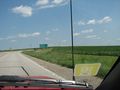
Made it to Danvers!
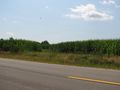
Hard to see, but this is the triangle shaped indentation you see in the overhead views
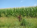
The hashpoint is beyond those stalks.
Too bad!
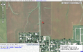
Overhead map...
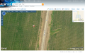
...and an aerial view.


Achievements
Dvdllr earned the No trespassing consolation prize
|