Difference between revisions of "2009-08-12 33 -84"
From Geohashing
imported>NWoodruff m (→Gallery) |
m |
||
| (2 intermediate revisions by 2 users not shown) | |||
| Line 34: | Line 34: | ||
== Achievements == | == Achievements == | ||
| − | |||
[[Category:Expeditions]] | [[Category:Expeditions]] | ||
[[Category:Coordinates not reached]] | [[Category:Coordinates not reached]] | ||
[[Category:Expeditions with photos]] | [[Category:Expeditions with photos]] | ||
| + | [[Category:Not reached - No public access]] | ||
| + | {{location|US|GA|FU}} | ||
Latest revision as of 09:57, 25 April 2022
| Wed 12 Aug 2009 in Atlanta: 33.6327078, -84.6304334 geohashing.info google osm bing/os kml crox |
Graticule
About
Expedition
NWoodruff
I looked at this hash point early in the day just as the market open price was released. It turned out to be in a pond of water. Being on as many Geohashes as I have been on, I knew not to rely on Google to place the exact point. I was hoping that when I got there that hash point would be in fact on land.
I drove there after work and made it out to the pond. It had a big iron fence that was right at the water line. It turns out that Google this time was correct and the Geohash point is in the water.
Gallery
- Photo Gallery
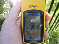
111 feet to go. It's going to be in the water.
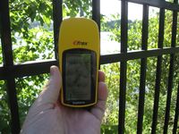
Somewhere right out there.
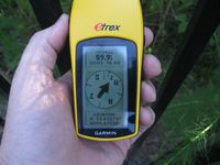
59.9 feet is as close as I could get with out a boat.
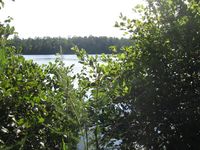
The hash point is somewhere right in the center of the picture.


