Difference between revisions of "2009-08-21 50 16"
From Geohashing
imported>MMlosh (basic page layout) |
imported>MMlosh (Archievments) |
||
| Line 22: | Line 22: | ||
Image:20090821 50 16-MML2.jpg|My bicycle at the hashpoint. | Image:20090821 50 16-MML2.jpg|My bicycle at the hashpoint. | ||
</gallery> | </gallery> | ||
| + | |||
| + | == Archieved achievements == | ||
| + | NOTE: I'll upload GPX log as OSM goes back online. | ||
| + | {{land geohash | ||
| + | |||
| + | | latitude = 50 | ||
| + | | longitude = 16 | ||
| + | | date = 2009-08-21 | ||
| + | | name = [[User:MMlosh|MMlosh]] | ||
| + | |||
| + | }} {{Bicycle geohash | ||
| + | |||
| + | | latitude = 50 | ||
| + | | longitude = 16 | ||
| + | | date = 2009-08-21 | ||
| + | | name = [[User:MMlosh|MMlosh]] | ||
| + | | distance = 19km + 23km | ||
| + | |||
| + | }} | ||
[[Category: Meetup on 2009-08-21]] | [[Category: Meetup on 2009-08-21]] | ||
Revision as of 15:13, 22 August 2009
| Fri 21 Aug 2009 in Wałbrzych: 50.0181646, 16.0780598 geohashing.info google osm bing/os kml crox |
Contents
About the place
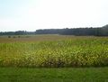
The hashpoint is on the side of corn field in village "Jaroslav", between cities "Holice" and "Choceň".
People={MMlosh};
Expedition description
"TODO" :(
Pictures
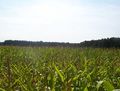
The corn field (taken from The point).
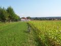
The "access road" (taken from The point).
My bicycle at the hashpoint.


Archieved achievements
NOTE: I'll upload GPX log as OSM goes back online.
MMlosh earned the Land geohash achievement
|
MMlosh earned the Bicycle geohash achievement
|