Difference between revisions of "2009-10-10 -19 146"
From Geohashing
imported>Mattyk |
imported>NWoodruff |
||
| Line 30: | Line 30: | ||
{{No trespassing|latitude=-19|longitude=146|date= 2009-10-10|name=[[User:Mattyk|Matty]]|image=2009-10-10 -19 146 03.jpg}} | {{No trespassing|latitude=-19|longitude=146|date= 2009-10-10|name=[[User:Mattyk|Matty]]|image=2009-10-10 -19 146 03.jpg}} | ||
| + | [[Category:Expeditions]] | ||
| + | [[Category:Expeditions with photos]] | ||
| + | [[Category:Coordinates not reached]] | ||
Revision as of 15:44, 22 August 2012
| Sat 10 Oct 2009 in -19,146: -19.4970651, 146.3456340 geohashing.info google osm bing/os kml crox |
Location
Not far from the Herveys Range Development Rd, maybe half an hour from Thuringowa. It appears to be a 350m hike through some semi-open bush.
Participants
Plan
I'm planning to head out there this morning with my girls and see if there's much potential. Semi-open scrubland like that tends to be pretty impassable, especially at this time of year. If it looks doable, I'll try to arrange a second expedition this afternoon; or at least let everyone else in the graticule know. –Matty 20:45, 9 October 2009 (UTC)
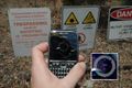
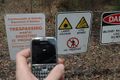
- Three words: Live Fire Range. At least it was a scenic drive, I don't head out west often enough. –Matty 04:13, 10 October 2009 (UTC)
Matty K's Expedition
In the words of the prophet: bugger it.
Only 130m that way!
Look, I'm so close...
Oh, no...
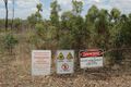
At least it doesn't say "You may die" this time.


Matty earned the No trespassing consolation prize
|