Difference between revisions of "2009-10-10 45 -123"
imported>Jiml m (Preliminary Report) |
imported>FippeBot m (Location) |
||
| (2 intermediate revisions by one other user not shown) | |||
| Line 7: | Line 7: | ||
== Location == | == Location == | ||
| − | Adjacent to a road in a | + | Adjacent to a road in a section of forest owned by Stimpson Lumber. |
| + | Close to Hagg Lake in Washington County, Oregon. | ||
== Participants == | == Participants == | ||
| Line 13: | Line 14: | ||
== Plans == | == Plans == | ||
| − | I programmed my GPS | + | On Friday, I noticed that the Friday and Saturday hashpoints looked possible, so |
| + | I programmed them into my GPS. I also let the local folks know about the possible | ||
| + | meet-ups via our local mailing list. | ||
== Expedition == | == Expedition == | ||
| − | |||
| − | |||
| − | + | Saturday, after I finished with the Farmer's Market and some errands, I | |
| + | went by home to see anyone would be joining me. No one had responded, so I | ||
| + | set off on my own. It turned into an "It's a kitty" expedition, I'm afraid. | ||
| + | |||
| + | My first distraction was something I'd seen a number of times before. I was taking | ||
| + | the backroads path to Highway 47 (AKA "going over the hill"), when I realized that there | ||
| + | was an old graveyard located on the roadway. There is no church nearby (anymore) and it | ||
| + | is pretty much this under-an-acre graveyard along a country road. I stopped to look at | ||
| + | it, and it has quite a mix: headstones from 1900 as well as last year. | ||
| + | |||
| + | From there I headed to Hagg Lake, I found the road that leads into the park, but | ||
| + | after going all the way around the lake, I finally found myself crossing over the dam and | ||
| + | heading out on the road I came in on, with no sign of the road I was supposed to take. | ||
| + | However, the lake and surrounding area was very pretty, and I kept stopping at lookout | ||
| + | points to look at the scenery. | ||
| + | |||
| + | A visit to the lumber plant revealed there was a road inbetween that Google Maps | ||
| + | didn't know about. The fact that the roads tended to curve around meant that | ||
| + | the GPS wasn't helpful. (However, Rhonda's Mom's trick of figuring out the | ||
| + | coordinates of the places you need to turn when taking forest roads might actually | ||
| + | have helped, if I can figure out a reliable way to get GPS coordinates out of | ||
| + | Google Maps.) | ||
| + | |||
| + | I crossed the dam again, and headed up the correct road, and found the correct road. | ||
| + | However, a permit was apparently required. When I got to the gate, I was met by | ||
| + | a retired state trooper who told me that during the week, this area was | ||
| + | actively logged, but on the weekends, at least during hunting season, you | ||
| + | could get a permit during the day to enter the road. However, all my Kitty | ||
| + | distractions had resulting in my getting there too late to try to reach the | ||
| + | hashpoint. | ||
| + | |||
== Photos == | == Photos == | ||
| − | |||
| − | |||
| − | |||
| − | |||
| − | |||
<gallery perrow="4"> | <gallery perrow="4"> | ||
| + | Image:2009-10-10_45_-123-grave1.jpg | The graveyard (AKA first Kitty) I found on my way to the hashpoint | ||
| + | Image:2009-10-10_45_-123-grave2.jpg | Larger view of the area | ||
| + | Image:2009-10-10_45_-123-Hagg1.jpg | View of Hagg Lake (second Kitty) | ||
| + | Image:2009-10-10_45_-123-Hagg2.jpg | Another view of Hagg Lake | ||
| + | |||
| + | Image:2009-10-10_45_-123-Trees.jpg | View along the road to the hashpoint | ||
| + | Image:2009-10-10_45_-123-navigator.jpg | I could try to blame my navigator, but that wouldn't be very nice | ||
</gallery> | </gallery> | ||
| − | + | == Achievements == | |
| − | + | ||
| − | [[ | + | {{No trespassing |
| − | + | | latitude = 45 | |
| + | | longitude = -123 | ||
| + | | date = 2009-10-10 | ||
| + | | name = [[User:Jiml|Jim]] | ||
| + | }} | ||
| + | |||
| + | {{It's a kitty | ||
| + | |||
| + | | latitude = 45 | ||
| + | | longitude = -123 | ||
| + | | date = 2009-10-10 | ||
| + | | name = [[User:Jiml|Jim]] | ||
| + | | distraction = a graveyard and a lake | ||
| + | }} | ||
[[Category:Expeditions]] | [[Category:Expeditions]] | ||
[[Category:Expeditions with photos]] | [[Category:Expeditions with photos]] | ||
| − | |||
[[Category:Coordinates not reached]] | [[Category:Coordinates not reached]] | ||
[[Category:Not reached - No public access]] | [[Category:Not reached - No public access]] | ||
| + | {{location|US|OR|WI}} | ||
Latest revision as of 06:15, 8 August 2019
| Sat 10 Oct 2009 in 45,-123: 45.4970651, -123.3456340 geohashing.info google osm bing/os kml crox |
Location
Adjacent to a road in a section of forest owned by Stimpson Lumber. Close to Hagg Lake in Washington County, Oregon.
Participants
Plans
On Friday, I noticed that the Friday and Saturday hashpoints looked possible, so I programmed them into my GPS. I also let the local folks know about the possible meet-ups via our local mailing list.
Expedition
Saturday, after I finished with the Farmer's Market and some errands, I went by home to see anyone would be joining me. No one had responded, so I set off on my own. It turned into an "It's a kitty" expedition, I'm afraid.
My first distraction was something I'd seen a number of times before. I was taking the backroads path to Highway 47 (AKA "going over the hill"), when I realized that there was an old graveyard located on the roadway. There is no church nearby (anymore) and it is pretty much this under-an-acre graveyard along a country road. I stopped to look at it, and it has quite a mix: headstones from 1900 as well as last year.
From there I headed to Hagg Lake, I found the road that leads into the park, but after going all the way around the lake, I finally found myself crossing over the dam and heading out on the road I came in on, with no sign of the road I was supposed to take. However, the lake and surrounding area was very pretty, and I kept stopping at lookout points to look at the scenery.
A visit to the lumber plant revealed there was a road inbetween that Google Maps didn't know about. The fact that the roads tended to curve around meant that the GPS wasn't helpful. (However, Rhonda's Mom's trick of figuring out the coordinates of the places you need to turn when taking forest roads might actually have helped, if I can figure out a reliable way to get GPS coordinates out of Google Maps.)
I crossed the dam again, and headed up the correct road, and found the correct road. However, a permit was apparently required. When I got to the gate, I was met by a retired state trooper who told me that during the week, this area was actively logged, but on the weekends, at least during hunting season, you could get a permit during the day to enter the road. However, all my Kitty distractions had resulting in my getting there too late to try to reach the hashpoint.
Photos
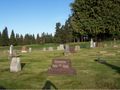
The graveyard (AKA first Kitty) I found on my way to the hashpoint
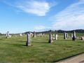
Larger view of the area
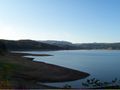
View of Hagg Lake (second Kitty)
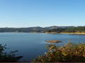
Another view of Hagg Lake
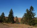
View along the road to the hashpoint

I could try to blame my navigator, but that wouldn't be very nice


Achievements
Jim earned the No trespassing consolation prize
|
Jim earned the It's a kitty consolation prize
|