Difference between revisions of "2009-10-21 30 -97"
imported>Lkearbey |
imported>FippeBot m (Location) |
||
| (4 intermediate revisions by 3 users not shown) | |||
| Line 4: | Line 4: | ||
| date=2009-10-21 | | date=2009-10-21 | ||
}} | }} | ||
| − | |||
| − | |||
__NOTOC__ | __NOTOC__ | ||
| Line 29: | Line 27: | ||
== Photos == | == Photos == | ||
<gallery> | <gallery> | ||
| − | Image:102109-01. | + | Image:102109-01.JPG|View from the passenger window |
| − | Image:102109-02. | + | Image:102109-02.JPG|View from out the windshield |
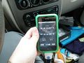
| − | Image:102109-03. | + | Image:102109-03.JPG|The coordinates on my iPhone. Please ignore the mess| |
</gallery> | </gallery> | ||
| Line 44: | Line 42: | ||
| name = Lkearbey | | name = Lkearbey | ||
}} | }} | ||
| + | |||
| + | |||
| + | [[Category:Not reached - No public access]] | ||
| + | [[Category:Expeditions with photos]] | ||
| + | [[Category:Expeditions]] | ||
| + | [[Category:Coordinates not reached]] | ||
| + | {{location|US|TX|TV}} | ||
Latest revision as of 06:27, 8 August 2019
| Wed 21 Oct 2009 in 30,-97: 30.4758602, -97.5423943 geohashing.info google osm bing/os kml crox |
Location
East of Toll-130, North of Kelly Ln on Hodde Ln. The area appears to be farm land on that side of the road but I know from experience that the maps of this area are outdated so it could be in the middle of a sub-division.
Participants
Plans
I will head that way after work, I should be there around 5:30pm local time
Expedition
After a quick pit stop at the house to pick up my camera I headed out to the coordinates. I made a few wrong turns along the way but got there in about 10 mins. I knew from looking at the map the coordinates would be on my left side, unfortunately I saw that most of the left side of the road was goat pasture and had 10 ft fences. There were a few cars behind me so I went past the coordinates and turned around. When I got near where I thought the hash would be I pulled off into the grass (which, looking back, was not a wise move considering all the rain we got in the morning). I pulled up my GPS app and saw that I was fairly close but knew I wasn't going to try and hop a 10 ft fence so I didn't bother with trying to get as close as possible.
I was a little disapointed that my first geohashing expedition was a failure but I think it's more about the journey than the destination. I learned a few things:
- I need to do a little research and find the best iPhone app for GPS, the ability to input coords and have it tell me proximity would be nice. I know the iPhone can't tell me direction unless I'm moving but proximity would be nice until I can afford a proper GPS unit (which I've been wanting for a while).
- I found Lake Pflugerville, I took a different path home and drove by the park at Lake Pflugerville, I've lived in the area for 1.5 years and never knew quite where it was
- I need to be mindful of ground conditions before I pull off the road, I don't have 4WD on my PT Cruiser and it would be relatively easy for me to get stuck. Alternatively I could take The Hubby's Jeep Wrangler for hashing expeditions!
Photos
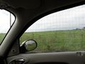
View from the passenger window
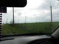
View from out the windshield


There was a little shelter behind me where all the goats were eating, I wish I had gotten a picture of it!
Achievements
Lkearbey earned the No trespassing consolation prize
|