Difference between revisions of "2010-01-24 -37 145"
imported>Jiml m (Add result categories) |
imported>Kozz (→Expedition) |
||
| Line 31: | Line 31: | ||
In a word: no. We pulled up to the closest point to the hashpoint, and disembarked from the car. A driveway, complete with gate and 'NO TRESPASSERS' sign, blocked our progress. We went on aways, thinking perhaps there would be easy access to a streamside path right to the hashpoint, but had absolutely no luck. We retraced our steps, trying to find access to the other side of the impeding line of properties, but ended up going kilometres the wrong way to gain only a few metres. | In a word: no. We pulled up to the closest point to the hashpoint, and disembarked from the car. A driveway, complete with gate and 'NO TRESPASSERS' sign, blocked our progress. We went on aways, thinking perhaps there would be easy access to a streamside path right to the hashpoint, but had absolutely no luck. We retraced our steps, trying to find access to the other side of the impeding line of properties, but ended up going kilometres the wrong way to gain only a few metres. | ||
| − | We returned to the road's closest point to the hash, and took the necessary proof photos - closest to hash: 298m. Stopped for an ice cream | + | We returned to the road's closest point to the hash, and took the necessary proof photos - closest to hash: 298m. I was determined to get at least some reward for the drive, so we picked up some geotrash on the way back to the car and dropped it off at the Yellingbo Roadhouse. Stopped for an ice cream then spent a relaxing evening on the deck with beer in hand reviewing the Hall of Amazingness stories from all around the world. |
Failed; No public access. | Failed; No public access. | ||
| − | + | == Photos == | |
| − | |||
| + | <gallery perrow="4"> | ||
| + | Image:2010-01-24_-37_145_Gravel roads.JPG | Gravel roads | ||
| + | Image:2010-01-24_-37_145_Getting closer.JPG | Getting closer | ||
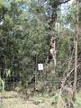
| + | Image:2010-01-24_-37_145_Trying to find hashpoint.jpg | Stopped, trying to find the hashpoint | ||
| + | Image:2010-01-24_-37_145_Neat pond.JPG | Neat little reservoir / lake complete with kayak | ||
| + | Image:2010-01-24_-37_145_300 metres away.JPG | Witty Comment | So close but so far! | ||
| + | Image:2010-01-24_-37_145_Proof of distance.JPG | Evidence that we did get close | ||
| + | Image:2010-01-24_-37_145_Geotrash.JPG | Geotrash is hard to come by here. Thank god. | ||
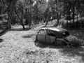
| + | Image:2010-01-24_-37_145_Old-car-2.jpg | Awesome old car rusting away nearby | ||
| + | Image:2010-01-24_-37_145_Old-car.jpg | Obligatory 'arty' photo | ||
| + | Image:2010-01-24_-37_145_Bush Panorama (Large).jpg | Panorama of nearby lake | ||
| + | Image:2010-01-24_-37_145_Yellingbo Roadhouse.JPG | The Yellingbo Roadhouse | ||
| − | |||
| − | |||
| − | |||
| − | |||
| − | |||
| − | |||
</gallery> | </gallery> | ||
| − | |||
| − | |||
| − | |||
| − | |||
| − | |||
| − | |||
| − | |||
| − | |||
| − | |||
| − | |||
| − | |||
| − | |||
| − | |||
| − | |||
| − | |||
| − | |||
| − | |||
| − | |||
| − | |||
| − | |||
| − | |||
| − | |||
| − | |||
| − | |||
| − | |||
| − | |||
| − | |||
| − | |||
| − | |||
| − | |||
| − | |||
[[Category:Expeditions]] | [[Category:Expeditions]] | ||
[[Category:Coordinates not reached]] | [[Category:Coordinates not reached]] | ||
[[Category:Not reached - No public access]] | [[Category:Not reached - No public access]] | ||
Revision as of 12:49, 24 January 2010
| Sun 24 Jan 2010 in -37,145: -37.8191506, 145.5349633 geohashing.info google osm bing/os kml crox |
Location
Edge of a reserve, south of Woori Yallock, Melbourne
Participants
Kozz + 2 drag alongs
Plans
We'll be heading out to the hashpoint with a target arrival time of about 4pm.
Expedition
The hash looked like it'd be easy enough to get to with Google Maps showing the access point as a strip of green, which often means 'public reserve'. The satellite view showed a strip of trees next to a road, and the Street View view of the start of the access road showed a promising-looking reserve signs. Beautiful - an outdoor hash, a nice day, and an area I'd never been to before.
After successfully dragooning friends into coming along and managing the GPS and satnav to get to the hashpoint, I picked up the drag-alongs and hit the road about 3pm. The drive was straightforward enough, taking us east of the city along the Maroondah highway, through part of the Yarra Valley wine region - absolutely beautiful on a summer day with blue skies above, rolling green fields around, and a lot to see and do.
We missed the turnoff to the main road and had to U-turn a little way down the road. Heading along the road towards the entry to the green zone, all was looking good. A Victoria Parks ute in a driveway; long stretches of dusty gravel roads leading down into the trees; surely success was imminent?
In a word: no. We pulled up to the closest point to the hashpoint, and disembarked from the car. A driveway, complete with gate and 'NO TRESPASSERS' sign, blocked our progress. We went on aways, thinking perhaps there would be easy access to a streamside path right to the hashpoint, but had absolutely no luck. We retraced our steps, trying to find access to the other side of the impeding line of properties, but ended up going kilometres the wrong way to gain only a few metres.
We returned to the road's closest point to the hash, and took the necessary proof photos - closest to hash: 298m. I was determined to get at least some reward for the drive, so we picked up some geotrash on the way back to the car and dropped it off at the Yellingbo Roadhouse. Stopped for an ice cream then spent a relaxing evening on the deck with beer in hand reviewing the Hall of Amazingness stories from all around the world.
Failed; No public access.
Photos
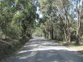
Gravel roads
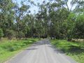
Getting closer
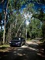
Stopped, trying to find the hashpoint
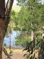
Neat little reservoir / lake complete with kayak
So close but so far!
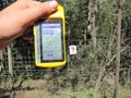
Evidence that we did get close
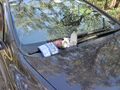
Geotrash is hard to come by here. Thank god.
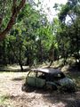
Awesome old car rusting away nearby
Obligatory 'arty' photo
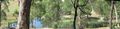
Panorama of nearby lake
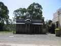
The Yellingbo Roadhouse


