Difference between revisions of "2010-03-28 45 -123"
imported>Jiml (Expand Template) |
imported>FippeBot m (Location) |
||
| (6 intermediate revisions by one other user not shown) | |||
| Line 1: | Line 1: | ||
| − | |||
<!-- If you did not specify these parameters in the template, please substitute appropriate things for IMAGE, LAT, LON, and DATE (YYYY-MM-DD format) | <!-- If you did not specify these parameters in the template, please substitute appropriate things for IMAGE, LAT, LON, and DATE (YYYY-MM-DD format) | ||
| Line 12: | Line 11: | ||
}} | }} | ||
| − | + | ||
| − | |||
== Location == | == Location == | ||
| − | + | North of Hwy 26, Near Bacona, Oregon, in the roadway | |
| + | |||
== Participants == | == Participants == | ||
| − | + | * [[User:Jiml|Jim]] | |
== Plans == | == Plans == | ||
<!-- what were the original plans --> | <!-- what were the original plans --> | ||
| + | Jim's planning on going. He's also dreaming about continuing on to | ||
| + | Clatskanie, but he'd have to get up fairly early to do that. | ||
| + | (But, not as early as those who left the day before to get to [[2010-03-28 global|Idaho]]!) | ||
== Expedition == | == Expedition == | ||
| − | + | Well, I didn't get up early to go geohashing and then head on over to the Columbia, which turned out | |
| + | to be just as good. I found the initial roads I was looking for, but I missed the turn off of the | ||
| + | paved road. Partly, I expected that a large green sign with two street names would be a little before | ||
| + | the street itself, especially if it is a 55MPH highway. But I forgot I'm in Oregon. | ||
| + | |||
| + | So, I turned around and headed back to the find what looked like a person's driveway, but really | ||
| + | was the road to the hashpoint. The soon-to-turn-to-gravel, one lane, windy road to the hashpoint. | ||
| + | As I'm driving up it, I'm thinking "I have a bad feeling about this" and "I wonder where I can turn around | ||
| + | without plunging off the rather steep slope to my right." The gravel road degraded to dirt | ||
| + | and then to very large rocks, making speeds larger than a few miles per hour very rough. | ||
| − | == | + | I encountered one road off to the left, but it seemed too soon, and it had a locked gate and |
| − | + | a sign that appeared to forbid access, so I continued on. The next road ended quickly with | |
| + | a locked gate, and didn't seem to head in the right direction, so I went back. | ||
| + | |||
| + | Closer inspection of the sign on the gate revealed that it didn't prohibit access except when we'd | ||
| + | be in the way or in danger. Weekends were okay, so I changed footgear and headed in. I started up | ||
| + | the fairly steep hill and found soon that the GPS was pointing to the left into very dense forest. | ||
| + | Clearly the other gate was the way to go, but I was hungry and tired, and the car was thirsty, and | ||
| + | I didn't remember the other gate was being quite a friendly as this one, so I gave up and headed out. | ||
| + | |||
| + | I headed a little bit north to Vernonia. There I found a gas station to feed my car. (It was a little | ||
| + | more expensive, but I felt I should support the local economy.) And I found a nice | ||
| + | cafe with Mediterranean food and had a gyro wrap that was very good. Vernonia got hit hard in | ||
| + | the floods a few years back, and has been struggling to recover. After my lunch, I went back | ||
| + | home to work on some projects there. | ||
| + | |||
| + | Upon getting home, I closely inspected the Google Satelite image and found the second road was | ||
| + | clearly the right one. I'll have to make a habit of printing that out for my next | ||
| + | trip to the logging roads. | ||
| + | |||
| + | === Second Expedition - April 25 Retrohash === | ||
| + | On April 25, I returned in another attempt to reach the hashpoint. I parked near, but out of the | ||
| + | way of the second ("less friendly") gate, and started in. I headed up a fairly steep grade, | ||
| + | and eventually found myself looking over the valley below. The geohash was still below me, but I | ||
| + | wasn't interested in crossing the slash and such to reach it. | ||
| + | |||
| + | I'd say Mother Nature won this one again. | ||
== Photos == | == Photos == | ||
| − | < | + | |
| − | Image: | + | === Original Expedition === |
| − | --> | + | <gallery perrow="4"> |
| + | |||
| + | Image:2010-03-28_45_-123-gate1.jpg|The first gate | ||
| + | Image:2010-03-28_45_-123-gate2.jpg|The second gate | ||
| + | Image:2010-03-28_45_-123-brush.jpg | The brush the GPS felt I should whack | ||
| + | Image:2010-03-28_45_-123-mist.jpg|A view of the area | ||
| + | |||
| + | </gallery> | ||
| + | |||
| + | === Jim's Apr 25 Retro Hash === | ||
<gallery perrow="4"> | <gallery perrow="4"> | ||
| + | Image:2010-03-28_45_-123-try2-gate.jpg | Gate to the hashpoint | ||
| + | Image:2010-03-28_45_-123-try2-road.jpg | The road up | ||
| + | Image:2010-03-28_45_-123-try2-road2.jpg.jpg |The road up | ||
| + | Image:2010-03-28_45_-123-try2-road3.jpg | The road up | ||
| + | Image:2010-03-28_45_-123-try2-slash.jpg | The way down | ||
| + | Image:2010-03-28_45_-123-try2-view.jpg | View from near the hashpoint | ||
| + | Image:2010-03-28_45_-123-try2-view2.jpg | View from near the hashpoint | ||
| + | Image:2010-03-28_45_-123-try2-view3.jpg | View from near the hashpoint | ||
</gallery> | </gallery> | ||
| − | |||
| − | |||
| − | |||
| − | |||
| − | |||
| − | |||
| − | |||
| − | + | ||
[[Category:Expeditions]] | [[Category:Expeditions]] | ||
| − | |||
[[Category:Expeditions with photos]] | [[Category:Expeditions with photos]] | ||
| − | |||
| − | |||
| − | |||
| − | |||
| − | |||
| − | |||
| − | |||
| − | |||
[[Category:Coordinates not reached]] | [[Category:Coordinates not reached]] | ||
| − | + | ||
| − | |||
[[Category:Not reached - No public access]] | [[Category:Not reached - No public access]] | ||
| − | + | {{location|US|OR|WI}} | |
| − | |||
| − | |||
Latest revision as of 01:21, 9 August 2019
| Sun 28 Mar 2010 in 45,-123: 45.7626321, -123.1763295 geohashing.info google osm bing/os kml crox |
Contents
Location
North of Hwy 26, Near Bacona, Oregon, in the roadway
Participants
Plans
Jim's planning on going. He's also dreaming about continuing on to Clatskanie, but he'd have to get up fairly early to do that. (But, not as early as those who left the day before to get to Idaho!)
Expedition
Well, I didn't get up early to go geohashing and then head on over to the Columbia, which turned out to be just as good. I found the initial roads I was looking for, but I missed the turn off of the paved road. Partly, I expected that a large green sign with two street names would be a little before the street itself, especially if it is a 55MPH highway. But I forgot I'm in Oregon.
So, I turned around and headed back to the find what looked like a person's driveway, but really was the road to the hashpoint. The soon-to-turn-to-gravel, one lane, windy road to the hashpoint. As I'm driving up it, I'm thinking "I have a bad feeling about this" and "I wonder where I can turn around without plunging off the rather steep slope to my right." The gravel road degraded to dirt and then to very large rocks, making speeds larger than a few miles per hour very rough.
I encountered one road off to the left, but it seemed too soon, and it had a locked gate and a sign that appeared to forbid access, so I continued on. The next road ended quickly with a locked gate, and didn't seem to head in the right direction, so I went back.
Closer inspection of the sign on the gate revealed that it didn't prohibit access except when we'd be in the way or in danger. Weekends were okay, so I changed footgear and headed in. I started up the fairly steep hill and found soon that the GPS was pointing to the left into very dense forest. Clearly the other gate was the way to go, but I was hungry and tired, and the car was thirsty, and I didn't remember the other gate was being quite a friendly as this one, so I gave up and headed out.
I headed a little bit north to Vernonia. There I found a gas station to feed my car. (It was a little more expensive, but I felt I should support the local economy.) And I found a nice cafe with Mediterranean food and had a gyro wrap that was very good. Vernonia got hit hard in the floods a few years back, and has been struggling to recover. After my lunch, I went back home to work on some projects there.
Upon getting home, I closely inspected the Google Satelite image and found the second road was clearly the right one. I'll have to make a habit of printing that out for my next trip to the logging roads.
Second Expedition - April 25 Retrohash
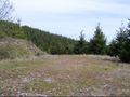
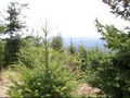
On April 25, I returned in another attempt to reach the hashpoint. I parked near, but out of the way of the second ("less friendly") gate, and started in. I headed up a fairly steep grade, and eventually found myself looking over the valley below. The geohash was still below me, but I wasn't interested in crossing the slash and such to reach it.
I'd say Mother Nature won this one again.
Photos
Original Expedition
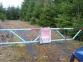
The first gate
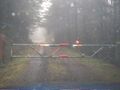
The second gate
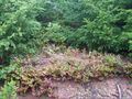
The brush the GPS felt I should whack
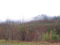
A view of the area


Jim's Apr 25 Retro Hash
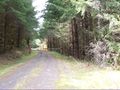
Gate to the hashpoint
The road up
The road up

The road up
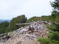
The way down
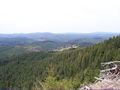
View from near the hashpoint
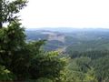
View from near the hashpoint
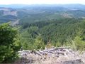
View from near the hashpoint


