Difference between revisions of "2010-04-30 53 -1"
imported>Scruffy Bumblebee m |
imported>FippeBot m (Location) |
||
| (2 intermediate revisions by 2 users not shown) | |||
| Line 26: | Line 26: | ||
== Images == | == Images == | ||
| + | <gallery perrow="5"> | ||
| + | Image:2010-04-30_53--1_CPbarbedwire.jpg | Confused Platypus contemplating his barbed wire options | ||
| + | Image:2010-04-30_53--1_cheesy.jpg | Cheesy grins despite our failure | ||
| + | Image:2010-04-30_53--1_googlemaps.jpg | Proof of our closeness to the hash/Confused Platypuses rubbishness | ||
| + | Image:2010-04-30_53--1_sadhash.jpg | Proof of Scruffy Bumblebees sadness | ||
| + | Image:2010-04-30_53--1_mirror.jpg | Our consolation toy... | ||
| + | </gallery> | ||
[[Category:Expeditions]] | [[Category:Expeditions]] | ||
[[Category:Coordinates not reached]] | [[Category:Coordinates not reached]] | ||
[[Category:Not reached - No public access]] | [[Category:Not reached - No public access]] | ||
| + | {{location|GB|ENG|NTT}} | ||
Latest revision as of 01:50, 9 August 2019
| Fri 30 Apr 2010 in 53,-1: 53.3599056, -1.0141990 geohashing.info google osm bing/os kml crox |
Contents
Location
Farmer's field, just off route home. Hash only just in field, next to a hedge.
People
The Plan
Park near field. Find handy public footpath/ farmers track around field. Follow footpath to next to hash point. Scamper in if field fallow/grass, or be satisfied with being pretty damn close. Celebrate not getting shot.
The Expedition
Parked near field. Found handy farmers track around field. Discovered Confused Platypus (all 6.5ft of him) was too scared of getting shot to even enter field, so gave it up as within 358 yards hashing failure and incident to mock Confused Platypus with. Celebrated not getting shot.
Images

Confused Platypus contemplating his barbed wire options
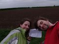
Cheesy grins despite our failure
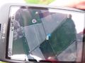
Proof of our closeness to the hash/Confused Platypuses rubbishness

Proof of Scruffy Bumblebees sadness
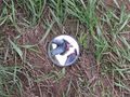
Our consolation toy...


