Difference between revisions of "2010-07-31 36 -86"
imported>BarrelRoller (Created page with '{{subst:Expedition |lat = 36 |lon = -86 |date = 2010-07-31 }}') |
imported>FippeBot m (Location) |
||
| (12 intermediate revisions by 2 users not shown) | |||
| Line 1: | Line 1: | ||
| − | |||
| − | |||
| − | |||
| − | |||
| − | |||
| − | |||
| − | |||
| − | |||
| − | |||
| − | |||
{{meetup graticule | {{meetup graticule | ||
| lat=36 | | lat=36 | ||
| lon=-86 | | lon=-86 | ||
| date=2010-07-31 | | date=2010-07-31 | ||
| + | | graticule_name=Nashville | ||
| + | | graticule_link=Nashville, Tennessee | ||
}} | }} | ||
| Line 19: | Line 11: | ||
== Location == | == Location == | ||
<!-- where you've surveyed the hash to be --> | <!-- where you've surveyed the hash to be --> | ||
| + | |||
| + | About 50 feet off the side of a country road just east of Cedars of Lebanon State Park, in Lebanon, TN, at | ||
| + | |||
| + | 36.060145°, -86.262923° | ||
== Participants == | == Participants == | ||
<!-- who attended --> | <!-- who attended --> | ||
| + | |||
| + | * [[User:BarrelRoller|Josh]] | ||
| + | * Wade | ||
== Plans == | == Plans == | ||
<!-- what were the original plans --> | <!-- what were the original plans --> | ||
| + | |||
| + | After Josh had a trip to Dinosaur World canceled (too high a risk of velociraptor attack), Josh was left with the desire for a roadtrip but had no apparent destination in mind. The idea of geohashing popped up into his head, so he managed to convince Wade to accompany him on what would be both of their first geohashing expeditions in their home graticule containing Nashville, TN. | ||
== Expedition == | == Expedition == | ||
<!-- how it all turned out. your narrative goes here. --> | <!-- how it all turned out. your narrative goes here. --> | ||
| − | + | After leaving Josh's apartment at about 3:45 p.m., we followed Wade's GPS as it guided us to the hash. It was a rather dull trip until we passed through Cedars of Lebanon State Park. We passed some horse crossings, an apparent wedding, and the usual foliage one would expect in a state park. We even stopped to say hello to a friendly, scruffy-looking dog. After passing a couple abandoned barns, we turned onto the street off which the hash was located. All was fine until we came up to a No Trespassing sign on the dead-end road. As we approached the sign, we noticed a dog jump off the porch of a house up ahead which started trotted towards the gate, so we took a couple pictures with the hash in the background but did not stay long. After beginning to back out towards the main road, we realized that our pictures did not actually contain us in them. Thus, we returned to the No Trespassing sign to remedy this minor error. The same dog trotted farther down the road towards us this time, accompanied by a second dog. Both began to bark at us. We then noticed a third dog on the porch, as well as the house's owner. Wade said he noticed something in the owner's hand, which he presumed to be a gun, so having completed picture-taking, we quickly reversed our way back towards the main road to return home. The trip back was marked by large ominous clouds and a chance encounter with Josh's aunt and uncle from Memphis. | |
| − | |||
== Photos == | == Photos == | ||
| Line 37: | Line 37: | ||
--> | --> | ||
<gallery perrow="5"> | <gallery perrow="5"> | ||
| + | Image:2010-07-31 36 -86 001.JPG|The expedition begins! | ||
| + | Image:2010-07-31 36 -86 002.JPG|Horse crossing | ||
| + | Image:2010-07-31 36 -86 003.JPG|A new friend! | ||
| + | Image:2010-07-31 36 -86 004.JPG|Stopping to say hi | ||
| + | Image:2010-07-31 36 -86 008.JPG|Friend acquired! | ||
| + | Image:2010-07-31 36 -86 005.JPG|Ah, this looks promising... | ||
| + | Image:2010-07-31 36 -86 006.JPG|Abandoned barn | ||
| + | Image:2010-07-31 36 -86 007.JPG|Noooo! | ||
| + | Image:2010-07-31 36 -86 009.JPG|The hash is just to the left of here | ||
| + | Image:2010-07-31 36 -86 010.JPG|0.1 miles away... | ||
| + | Image:2010-07-31 36 -86 011.JPG|Map of hash location | ||
| + | Image:2010-07-31 36 -86 012.JPG|How close we actually got | ||
| + | Image:2010-07-31 36 -86 013.JPG|Wade is disappointed... | ||
| + | Image:2010-07-31 36 -86 014.JPG|The crew | ||
| + | Image:2010-07-31 36 -86 016.JPG|The welcome party | ||
| + | Image:2010-07-31 36 -86 015.JPG|Lovely weather | ||
</gallery> | </gallery> | ||
| Line 42: | Line 58: | ||
{{#vardefine:ribbonwidth|800px}} | {{#vardefine:ribbonwidth|800px}} | ||
<!-- Add any achievement ribbons you earned below, or remove this section --> | <!-- Add any achievement ribbons you earned below, or remove this section --> | ||
| + | {{No trespassing | ||
| + | | latitude = 36 | ||
| + | | longitude = -86 | ||
| + | | date = 2010-07-31 | ||
| + | | name = BarrelRoller | ||
| + | |image = 2010-07-31_36_-86_013.JPG | ||
| + | }} | ||
| − | |||
| − | |||
| − | |||
| − | |||
| − | |||
| − | |||
| − | |||
| − | |||
| − | |||
| − | |||
[[Category:Expeditions]] | [[Category:Expeditions]] | ||
| − | |||
[[Category:Expeditions with photos]] | [[Category:Expeditions with photos]] | ||
| − | |||
| − | |||
| − | |||
| − | |||
| − | |||
| − | |||
| − | |||
[[Category:Coordinates not reached]] | [[Category:Coordinates not reached]] | ||
| − | |||
| − | |||
[[Category:Not reached - No public access]] | [[Category:Not reached - No public access]] | ||
| − | + | {{location|US|TN|WO}} | |
| − | |||
| − | |||
Latest revision as of 03:23, 6 August 2019
| Sat 31 Jul 2010 in Nashville: 36.0601459, -86.2629227 geohashing.info google osm bing/os kml crox |
Location
About 50 feet off the side of a country road just east of Cedars of Lebanon State Park, in Lebanon, TN, at
36.060145°, -86.262923°
Participants
- Josh
- Wade
Plans
After Josh had a trip to Dinosaur World canceled (too high a risk of velociraptor attack), Josh was left with the desire for a roadtrip but had no apparent destination in mind. The idea of geohashing popped up into his head, so he managed to convince Wade to accompany him on what would be both of their first geohashing expeditions in their home graticule containing Nashville, TN.
Expedition
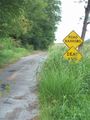
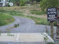
After leaving Josh's apartment at about 3:45 p.m., we followed Wade's GPS as it guided us to the hash. It was a rather dull trip until we passed through Cedars of Lebanon State Park. We passed some horse crossings, an apparent wedding, and the usual foliage one would expect in a state park. We even stopped to say hello to a friendly, scruffy-looking dog. After passing a couple abandoned barns, we turned onto the street off which the hash was located. All was fine until we came up to a No Trespassing sign on the dead-end road. As we approached the sign, we noticed a dog jump off the porch of a house up ahead which started trotted towards the gate, so we took a couple pictures with the hash in the background but did not stay long. After beginning to back out towards the main road, we realized that our pictures did not actually contain us in them. Thus, we returned to the No Trespassing sign to remedy this minor error. The same dog trotted farther down the road towards us this time, accompanied by a second dog. Both began to bark at us. We then noticed a third dog on the porch, as well as the house's owner. Wade said he noticed something in the owner's hand, which he presumed to be a gun, so having completed picture-taking, we quickly reversed our way back towards the main road to return home. The trip back was marked by large ominous clouds and a chance encounter with Josh's aunt and uncle from Memphis.
Photos
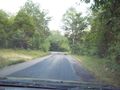
The expedition begins!
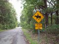
Horse crossing
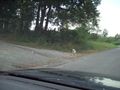
A new friend!
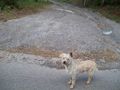
Stopping to say hi
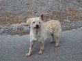
Friend acquired!
Ah, this looks promising...
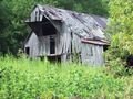
Abandoned barn
Noooo!
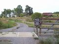
The hash is just to the left of here
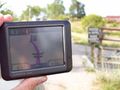
0.1 miles away...
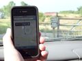
Map of hash location
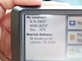
How close we actually got
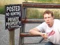
Wade is disappointed...
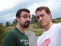
The crew
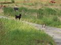
The welcome party
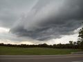
Lovely weather


Achievements
BarrelRoller earned the No trespassing consolation prize
|